Orbital Assets

Why is it important?

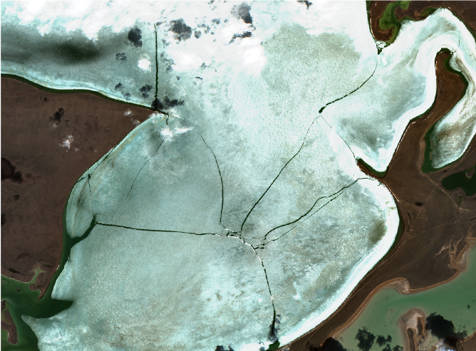
Earth Observation (EO) technology holds significant potential as a synoptic means to map and monitor building assets and material stocks in urban environments - thus providing key information to improve resource efficiency and circularity within the building and construction sector. This project will uncover the potential of EO and advanced machine learning technology to map building objects and elements and assess the typology of potentially reusable building material/deposits in urban areas to underpin circular economy objectives.

Project highlights:

Analysing and documenting needs and requirements for geoinformation data solutions amongst key stakeholders in the building and construction industry

Assessing the technical feasibility of EO solutions to map and monitor material stocks and building condition, in line with the needs and requirements of the key stakeholders.

Demonstrating the application of EO solutions to improve reuse and recycling of material stocks and underpin smarter building maintenance frameworks in the building and construction industry.

In more detail..

Construction and demolition waste makes up 41 % of the total waste generation in Denmark and just over one third of the total waste generation in the EU. However, despite relatively high recovery rates of used materials in most EU countries, most of the recovery of construction waste is largely based on low-grade backfilling operations. Higher and better-quality recycling of existing building materials is needed to reduce the carbon footprint of the construction industry, and ultimately reduce costs – yet largely incomplete and outdated information about existing building assets impedes efforts to make longer term planning and integrate such resources in existing/future projects.

Earth Observation (EO) technology holds significant potential to address this data gap as a timely and synoptic resource to provide up to date information about urban objects as well as resource availability, location, typology, and condition. Thus, EO could provide new avenues for improving resource efficiency and circularity within the building and construction sector – and tap into a market believed to be worth between 10-12 million € per year, in Denmark alone.

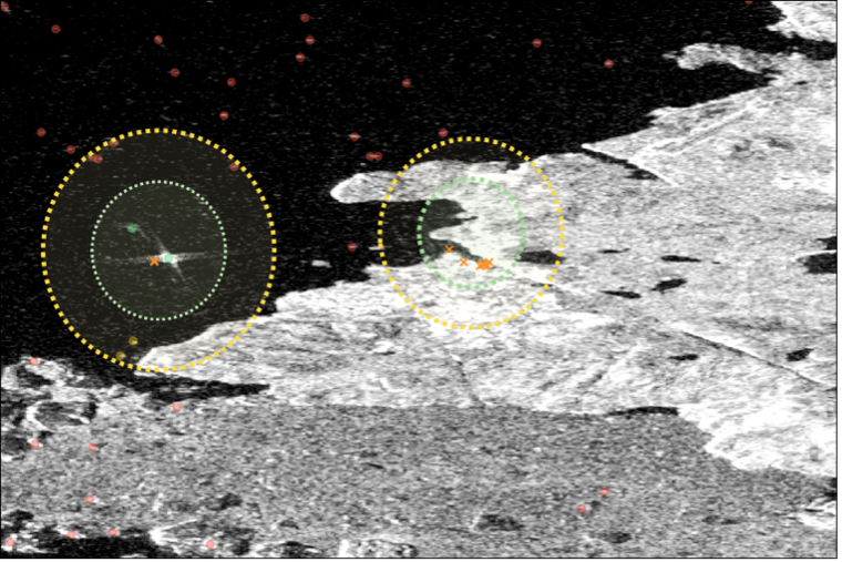
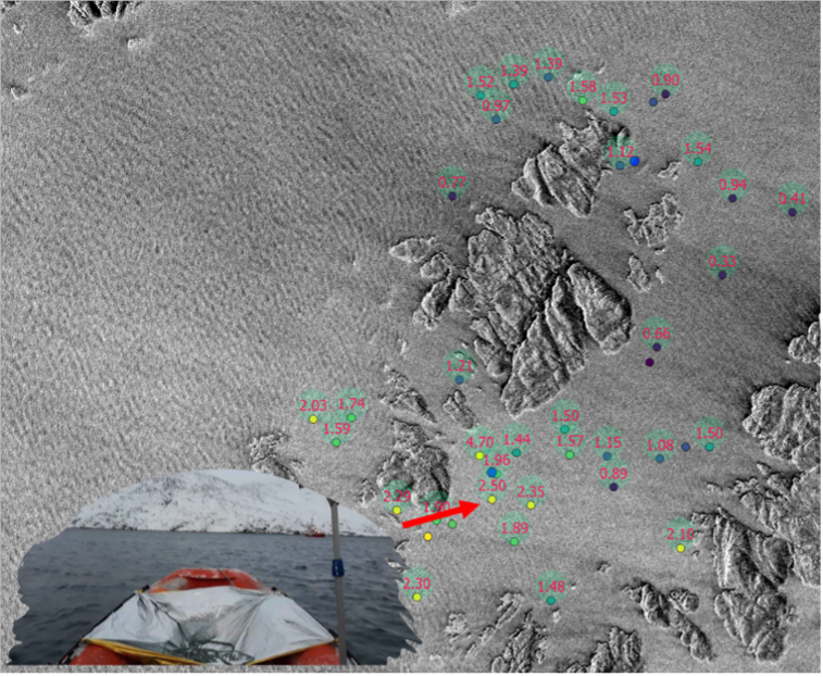
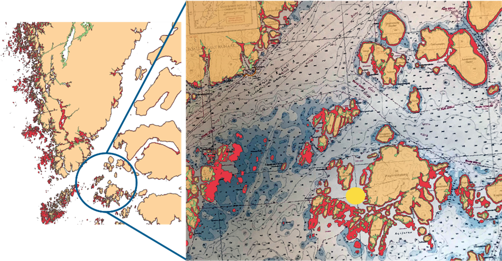
Orbital Assets will explore the potential of novel deep learning technology and Copernicus Sentinel data, in addition to aerial photos, lidar data, street view imagery and other relevant data sources, to assess and monitor built environments and objects/materials on individual buildings and their surroundings.

The primary objectives are to identify and test the potential of EO solutions to:

    1) Quantify and qualify existing building resources by exploring the application of deep learning algorithms and a variety of EO data sources to systematically map, monitor and count different building objects with a view to estimate the availability of potentially reusable building material. The potential of such application could underpin new ways to adapt and built assets in line with circular principles for building design, thus contributing to reduce the carbon footprint of the construction industry and ultimately, reduce costs.

    2) Improve building maintenance frameworks by exploring the application of deep learning technology and EO data sources to automatically monitor the health and condition of individual buildings as well as their surroundings. The intention of the activity is to explore the feasibility of deep learning and EO data to detect and map parameters such as, larger cracks in bricks, windows, pipes and facades; faded or peeling paint; vegetation overgrow; weathered, missing or damaged rooftop shingles; damaged solar cells and other relevant parameters.
The project is implemented in partnership with ORCA, experts of circular solutions in the urban domain.

European Space Agency:

About ESA and ESA Space Solutions:

The European Space Agency (ESA) is Europe’s gateway to space. ESA is an intergovernmental organisation, created in 1975, with the mission to shape the development of Europe’s space capability and ensure that investment in space delivers benefits to the citizens of Europe and the world. European Space Agency (esa.int)

ESA Space Solutions is the go-to place for great business ideas involving space in all areas of society and economy. Its mission is to support entrepreneurs in Europe in the development of business using satellite applications and space technology to improve everyday life. ESA Space Solutions

EOatDHI part of the DHI GROUP

gras@dhigroup.com
+45 4516 9100

Agern Alle 5,
2970 Hørsholm,
Denmark

CVR: 36466871

SAR4SAR – Enhancing Arctic Search and Rescue operations using radar satellite imagery

Why is it important?

Maritime activity across the Arctic is increasing together with increased economic activity and geopolitical awareness in the region. The increased traffic is mainly due to fishing, bulk carrier traffic, mineral exploration activities, cruise tourism but also an increasing need for sovereignty enforcement capabilities. Adding to this, local traffic, of which smaller fishing vessels, recreational boating, and local tourist operators are the main purposes.

Consequently, supporting safety at sea, safeguarding national sovereignty as well as offering support to the civil society, efficient and capable naval and first responding capacities are being important as ever before to Arctic societies and nations. As examples of this, in Greenland alone, every year more than 50 search-and-rescue operations take place, where smaller boats and dinghies (dark-vessels) are involved.

Also, cruise tourism in the Arctic is expected, post-COVID-19, to attract even more tourists. These cruise ships often carry well over 500 passengers and in the event of an emergency situation where life rafts have to be used, there will be a pronounced need to provide an overview of the positions of these rafts, as they can quickly spread over large areas, due to rough environmental conditions.

All in all, the increased Arctic maritime traffic constitutes an increasing safety risk element, which is why increased capabilities concerning the location of small maritime objects and dark-vessel detection are required.

Project highlights:

Exploring how Danish companies within the marine, security and defense sectors can contribute with solutions increasing the visibility of small maritime objects in radar satellite images.

Feasibility live tests of equipment and tech solutions under Arctic conditions, securing Arctic-fit solutions.

Bridging scientific and industry knowledge and experience, safeguarding scientific and industry excellence and requirements.

In more detail..

Maritime activity across the Arctic is increasing together with increased economic activity and geopolitical awareness in the region. Supporting safety at sea, safeguarding national sovereignty as well as offering support to the civil society, efficient and capable naval and first responding capacities are being important as ever before to Arctic societies and nations and a clear need for enhanced navigational situational awareness exists.

Adding to this, communication opportunities in the Arctic are often limited outside the populated areas, due to vast distances and lack of communication infrastructure. In the case of dark-vessel-detection, e.g. for search-and-rescue operations, navies and first responders often have to search vast areas with little opportunity to efficiently identify the exact location of those in need in the often harsh environmental conditions.

Satellite-based decision support allows among other things efficient object identification within large areas. However, satellite-based object identification in the Arctic is challenged by a number of factors, including cloud cover, limited sunlight much of the year as well as large geographical areas, and widespread lack of up-to-date coastal information. SAR (Synthetic Aperture Radar) based sensors utilize microwave reflection against a given surface and can thus operate independently of cloud cover and light conditions, which is why SAR-based satellite data is particularly suitable under Arctic conditions.

The challenge of object identification in connection with search-and-rescue operations using SAR satellite data is that publicly available, e.g., Sentinel 1 from the European Space Agency (ESA), does not offer a sufficiently high spatial resolution to determine objects smaller than about 20m. In addition, the temporal resolution is also too low (3-5 days return visit time) to provide near-real-time data.

Due to recent and substantial expansion in commercial satellite constellation capabilities, it is possible to obtain high temporal and spatial resolution radar satellite data. However, detecting small maritime objects and dark vessels remains a challenging task and therefore SAR4SAR will explore how these challenges can be overcome by combining research and industry knowledge and tested in a live environment.

Center for Defence, Space & Security:

The Center for Defence, Space & Security (CenSec) is the prime Danish cluster for small and medium-sized enterprises specializing in high tech industries like defence, homeland security, space, aerospace, railway and maritime.

CenSec was founded in 2004 and established in 2007 as an industrial cluster. In 2018, CenSec was approved by the Danish Ministry of Higher Education and Science to also become a national Innovation Network for Security (Inno-Sec)

Related items

AI4ALERT

Developing novel geointelligence solutions to underpin security and defence related needs and requirements

Read More

Global Seas

Delivering earth observation enriched high-quality metocean data to enhance fuel efficiency in the shipping industry. . . .

Read More

EOatDHI part of the DHI GROUP

gras@dhigroup.com
+45 4516 9100

Agern Alle 5,
2970 Hørsholm,
Denmark

CVR: 36466871

MOOD Decom – MetOcean On Demand Decommissioning (Feasibility study)

Why is it important?

Decommissioning of offshore energy assets is set to become a huge task in the coming years for both operators of the assets and authorities; a task that comes with a cost of 100’s of billions of euros globally. Considering this, activities offering a cost reduction will have significant impact – and interest – for the decommissioning stakeholders, even more if activities furthermore offer reduced health and safety issues and better control of environmental impacts.

The MOOD Decom Feasibility Study sets out to assess and explore the value of applying satellite earth observation data for providing accurate metocean data with quantified uncertainty for securing safe, compliant, efficient and cost-effective solutions for the decommissioning activities foreseen for European offshore energy assets over the coming years and decades.

Project highlights:

Feasibility study evaluating EO-enriched metocean services for compliant, safe and efficient end-to-end decommissioning operations that are most business critical.

EO-enriched metocean data with quantified uncertainties and probabilistic measures of workability for short and long-term planning of operations.

More efficient and safer operations with associated lower costs for decommissioning stakeholders.

In more detail..

The decommissioning of energy assets entails a chain of complex decisions on environmental impact risks, logistics and worker safety. Operations are strongly affected by several environmental influences such as tides, currents, waves, winds, sea temperature and salinity.

Today’s decision-making is typically based on metocean data analyses, for instance by assessing how often the significant wave height is less than a certain threshold during a given period. Actual decision drivers, such as heavy lift vessel motions, drag on an underwater remotely operated vehicle by currents, scour holes around the legs of jack-up vessels, are not directly addressed. This leads to either unnecessary conservativism or risk underestimation resulting in sub-optimal cost-efficiency.

MOOD Decom will support decommissioning industry and operators in Oil & Gas and Offshore Wind with:

  • High-quality metocean information with quantified uncertainties
  • Integration of metocean data with probabilistic measures of workability
  • Near-real-time metocean parameters for environmental impact monitoring
The activity will establish an easy-to-use online tool, where the assimilation and fusion of EO-data in near-real time will ingest satellite data into a forecast service providing information of metocean conditions near installations at sea and along routes to/from the installations.

Parallel to the operational forecast system, we will establish a database of metocean hindcast-data with historical information of relevant parameters for the long-term planning of operations at sea. These two parallel systems will form the backbone of a new DHI operated decommissioning decision support system, enabling more efficient and safer operations with associated lower costs for decommissioning stakeholders.

European Space Agency:

The European Space Agency (ESA) is the European space programme and its mission is to explore Earth, its immediate space environment, our Solar System and the Universe.

ESA also works closely with space organisations outside Europe to develop satellite-based technologies and services, and to promote European industries. ​

Related items

Global Seas

Delivering earth observation enriched high-quality metocean data to enhance fuel efficiency in the shipping industry. . . .

Read More

EOatDHI part of the DHI GROUP

gras@dhigroup.com
+45 4516 9100

Agern Alle 5,
2970 Hørsholm,
Denmark

CVR: 36466871

NANOK – Nautical Navigation Operational Knowledge

Why is it important?

Maritime operations in the Arctic are often associated with high level of navigational risk since access to reliable nautical charts is limited by the fact that existing charts are often several nautical miles off, with vast areas still uncharted.

Meanwhile, the level of human activity in the Arctic is increasing. Climate changes widens the areas of operation in the Arctic, with ice-free conditions, enabling expansion of economic activities, access to natural resources and opening of new shipping routes. Also, increased research and tourism activities leads to an increase in marine traffic across the Arctic region.

In all, this leads to an enlarged geopolitical awareness of the Arctic region and in turn also an intensified military awareness and presence in the region.

The Danish Defense undertakes several tasks in the Arctic, including enforcement of sovereignty, search and rescue operations, fishing controls as well as societal tasks, e.g., scientific and medical logistical support. In this context NANOK provides the much-needed navigational situational awareness reducing navigational risks in the Arctic region.

Project highlights:

NANOK develops an automation and upscaling feasibility study of navigational hazards including 1) submerged rocks, 2) coast lines and 3) intertidal zones applicable to all arctic regions.

The NANOK data products are tailored to naval navigation systems and user requirements.

NANOK data products are processed in a cloud-computing environment allowing rapid data production and updating.

In more detail..

Maritime activity across the Arctic is increasing together with an increased geopolitical awareness in the region. Maritime operations in the Arctic are associated with high level of navigational risk since access to reliable nautical charts is limited by the fact that existing charts are often several nautical miles off, with vast areas still uncharted.

This situation often leaves navigators with on board equipment such as different types of sonar systems, offering little decision support on route planning and forward-looking situational awareness at a larger scale. The activities in the NANOK project are expected to significantly support route planning and situational awareness for a wide range of both civil and naval tasks.

NANOK is co-financed by and developed in collaboration with the Danish Defence and data products are consequently tailored to specific naval user requirements through dialogue-based co-production and onboard field testing.

The NANOK project develops Arctic navigational risk minimization by mapping submerged rocks, intertidal zones and coast lines. It includes an automation and upscaling feasibility test in Greenland of two previously developed remote sensing processing chains:

  • Mapping of Arctic shallow water areas using a DHI GRAS proprietary multitemporal bathymetric retrieval model based on open-source satellite data, validated against in-situ multi-beam echo sounding data.
  • Mapping of Arctic coastlines using a DHI GRAS proprietary method involving satellite data, intertidal information, machine learning.
The project reaches out to international Arctic stakeholders paving the way for a further product development and pan-arctic navigational risk minimization.

NANOK is co-financed by the Danish Defence Acquisition and Logistics Organization and DHI GRAS and is supported by the Danish Naval Warfare Centre and the Danish Defence Joint GeoMETOC Support Center.

Related items

EOatDHI part of the DHI GROUP

gras@dhigroup.com
+45 4516 9100

Agern Alle 5,
2970 Hørsholm,
Denmark

CVR: 36466871

AI4ALERT

Why is it important?

Satellite technology has been through explosive development in recent years and new sensors with augmented capabilities – even entire constellations of microsatellites – are sent into space on a regular basis. As a result, satellite data provides new avenues to underpin time-critical geointelligence solutions. This project will uncover existing needs and requirements for security and defence related geointelligence solutions among stakeholders in Denmark and demonstrate how these can be addressed through novel satellite-based applications.

Project highlights:

Analysing and documenting existing needs and requirements for time-critical geointelligence solutions among key stakeholders in defence and security.

Developing novel geointelligence solutions through the application of deep learning technology and multisource earth observation data.

Demonstrating and testing the potential of satellite-based geointelligence solutions through application in relevant use case scenarios and provision of tailormade webinars to connect industry leaders and relevant stakeholders in the security and defence related sectors.

In more detail..

Satellite technology has been through rapid development in recent years and every day, hundreds of satellites orbit above us in space with one purpose – to acquire and deliver timely data and information about our planet. Combined with new and improved data handling and processing capabilities, cloud computing and machine learning, satellite data provides new avenues to improve and augment geointelligence capacities and solutions.

Artificial Intelligence for Acute Living Earth Reconnaissance Technology “AI4ALERT” aims to uncover existing needs for time-critical geointelligence solutions among stakeholders working with critical infrastructure or otherwise operate within a defense and security context.

Through a series of bilateral meetings and online webinars with key stakeholders, the project will seek to connect industry leaders and document existing technology gaps and unmet needs for geointelligence. Consequently, the project will demonstrate how the combination of novel satellite data sources and deep learning technology can power scaleable, autonomous and intelligent solutions to address a variety of these needs.

Examples of such services include:
  • Monitoring critical infrastructure (e.g. detecting fallen trees or other obstacles on roads and railways, monitoring vegetation growth in the vicinity of electrical grids, detecting unapproved excavation work nearby power- and gas lines, monitoring soil moisture to detect waterpipe leaks, mapping flooded roads as well as general dynamic monitoring of traffic movement);
  • Tracking and monitoring activity patterns and movement in operational scenarios (i.e., detecting and monitoring the number of people and cars to provide insight into activity patterns and early warnings for unusual activities);
  • Monitoring the impact of emergency events (e.g. the extent of flooding’s and identification of people and housing impacted, monitoring fire risk and ongoing fire extent and movement, detecting and tracking oil spills, etc.).
Such solutions and information services could underpin a range of core geointelligence needs among a wide range of private and public stakeholders in both Denmark and internationally, including emergency authorities, the police, the defence, national security agencies, airports, ports and harbors, utilities and insurance companies.

Center for Defence, Space & Security:

The Center for Defence, Space & Security (CenSec) is the prime Danish cluster for small and medium-sized enterprises specializing in high tech industries like defence, homeland security, space, aerospace, railway and maritime.

CenSec was founded in 2004 and established in 2007 as an industrial cluster. In 2018, CenSec was approved by the Danish Ministry of Higher Education and Science to also become a national Innovation Network for Security (Inno-Sec)

EOatDHI part of the DHI GROUP

gras@dhigroup.com
+45 4516 9100

Agern Alle 5,
2970 Hørsholm,
Denmark

CVR: 36466871

Digital Ortho Photos of Ice free Greenland from existing Satellite imagery 2020

Why is it important?

Topographic maps of Greenland are generally outdated, and the positional accuracy often inadequate, in the open land outside the main settlement areas.

This means that critical decisions relevant for public administration and environmental regulation are often based on inadequate data and information, thus impeding the ability of authorities to make informed and data driven decisions rooted in the best possible data.

The new up to date orthophoto mosaics based on the latest satellite imagery from the Airbus Spot 6/7 satellites will contribute to address this gap by providing a fresh view of the ice-free areas of Greenland.

Project highlights:

Provision of very high resolution satellite imagery covering 225.000 km2 of Greenland

Advanced large scale data processing to produce seamless cloud-free, orthorectified and color optimized image mosaics covering the entire 225.000 km2.

Independent advice and support on satellite data selection and processing, drawing upon more than 20 years’ experience

In more detail..

Since 2015, DHI GRAS has supported the Danish Agency for Data Supply and Efficiency (SDFE), in close cooperation with Greenland’s Government, in their mission to provide updated topographic maps of the ice-free areas of Greenland.

The current topographic maps of Greenland are based on data collected in the 1930s and 1970-80s and they are inaccurate both in terms of elevation, distance and geolocation. However, Greenland is a large country and combined with the extreme conditions, dark polar winters and frequent cloud cover makes it difficult and costly to map at scale through traditional means.

Through previous pilot projects (undertaken in collaboration with Airbus on behalf of SDFE), we have provided ready-to-use orthomosaics and detailed Digital Elevation Models (DEM) for an area covering 85.000 sqkm of Greenland, successfully demonstrating the viability and potential of satellite imagery as a solution to the existing data gap.

In this project (in collaboration with Airbus) we will deliver updated satellite ortho image mosaics for the majority of the ice-free areas of Greenland – covering an extent of more than 225.000 km2.

These new data, providing a fresh view of Greenland, will underpin efforts to update existing topographic maps, thus contribute to support informed decision making and make it easier and more secure to navigate in the vast Greenlandic nature.

In partnership with

Danish Agency for Data Supply and Efficiency:

The Danish Agency for Data Supply and Effeciency (SDFE) provides high-quality data to the public and private sectors, enabling them to make important community decisions on the best possible basis.

SDFE is an agency that spans broadly across public administration and is part of the Danish Ministry of Climate, Energy and Utilities.

Related items

EOatDHI part of the DHI GROUP

gras@dhigroup.com
+45 4516 9100

Agern Alle 5,
2970 Hørsholm,
Denmark

CVR: 36466871

NextLand

Why is it important?

More efficient use of water, and other inputs, in agriculture is gaining importance with recent attention to sustainable resource use. By providing timely, accurate and field-scale information on the crop water use and crop water needs we can help farmers to optimize their practices with both economic and environmental benefits.

Project highlights:

Satellite data can be used to operationally produce potential and actual evapotranspiration maps.

Actionable information, such as crop water deficit, can be used by farmers to improve their irrigation practices.

NextLand store will allow easy access to produced maps through a modern user and machine-to-machine interfaces.

In more detail..

With the Copernicus Earth observation program reaching a mature stage, the time is right to develop operational commercial services based on this high-quality data. This is the aim on the NextLand project, with the focus on agricultural and forestry EO services. At DHI GRAS we have been developing advanced methods to estimate actual and potential evapotranspiration using data from the Copernicus Sentinel satellites and infer crop water needs based on this information. This is the expertise which we are bringing to the NextLand consortium. Through co-creation with selected group of agricultural alpha-users we will fine-tune our evapotranspiration-based products and offer a valuable tool for optimizing irrigation practices with benefits both to the farmers and the environment.

European Commission:

NextLand is funded by the European Union’s H2020 Programme for Research, Technological Development and Demonstration.

H2020 is the biggest EU Research and Innovation programme and a financial instrument aimed at securing Europe’s global competitiveness by driving economic growth and focusing on research as an investment for the future of Europe.

EOatDHI part of the DHI GROUP

gras@dhigroup.com
+45 4516 9100

Agern Alle 5,
2970 Hørsholm,
Denmark

CVR: 36466871

Increasing Crop Water Use Efficiency at Multiple Scales Using Sentinel Evapotranspiration – ET4FAO

Why is it important?

With increasing pressure on fresh water resources, and up to 70% of those resources used in crop irrigation, it is important to monitor and improve crop water use efficiency from field to national scales.

Project highlights:

Evaporanspiration maps covering Lebanon and Tunisia were produced and are available from et4fao.dhigroup.com

Covering a wide range of metocean parameters with expert assessment of quality and only including sufficiently reliable data.

Robust scientific analysis of the new evapotranspiration products and maps available from WaPOR portal is conducted.

In more detail..

The Food and Agriculture Organization (FAO), the custodian agency of SDG indicators 6.4.1 and 6.4.2, is running a portal called Water Productivity Open-access portal (WaPOR) to encourage the use of satellite data in crop water use efficiency monitoring. The WaPOR portal currently relies on Terra and Aqua, PROBA-V and Landsat satellite data, many of which are at the end of their expected lifetime. In this project we perform robust, scientific analysis of the possibility to use Copernicus data (especially observations from the Sentinel-2 and Sentinel-3 satellites) in place of the legacy satellites, to produce national maps of evapotranspiration able to capture field-scale crop water use.

The project builds upon methodologies developed during the ESA-funded Sen-ET project. During that project, a robust method was developed to estimate land-surface energy fluxes, including evapotranspiration, at field-scale using Sentinel-2 and Sentinel-3 data, despite the absence of a high-resolution thermal sensor in the Sentinel constellation. The method consisted of a machine-learning data fusion algorithm for sharpening land surface temperature measured by Sentinel-3 at 1 km to the 20 m spatial resolution of Sentinel-2, followed by a physically based modelling of land-surface energy fluxes. In ET4FAO we apply this technique to produce evapotranspiration maps covering the whole of Lebanon and Tunisia at 20 m, 100 m and 300 m spatial resolutions. Those maps are then compared against products available from the FAO WaPOR portal and validated against independent field measurements.

European Space Agency:

The project in funded by ESA as part of the EO Science for Society Open Call. It is a partnership between scientists from DHI GRAS and COMPLUTIG (Spain) with FAO acting as the main stakeholder.

EOatDHI part of the DHI GROUP

gras@dhigroup.com
+45 4516 9100

Agern Alle 5,
2970 Hørsholm,
Denmark

CVR: 36466871

Marine vegetation mapping in Sweden

Why is it important?

According to the EU Habitat directive and the Marine Strategy Framework Directive, member states are required to map, monitor and evaluate changes in the quality and areal distribution of different marine habitats and biotopes. Submerged aquatic vegetation (SAV), in particular eelgrass, is one of the key indicators of ecological status and environmental state of water bodies, and therefore widely used in reporting related to these directives.

Project highlights:

Copernicus Sentinel-2 imagery, novel machine learning techniques and advanced data processing to create the first spatial overview of the distribution of SAV at national scale in Sweden.

A cloud-based web-application for Sentinel-2 based SAV mapping without prior specialist knowledge Input.

A training dataset constructed with more than 30 000 manually drawn polygons to build a robust machine learning model and predict nationwide SAV.

In more detail..

In 2020 we embarked on a project together with the Swedish regional and national authorities, to combine Copernicus Sentinel-2 satellite imagery, novel machine learning techniques and advanced data processing to create the first spatial overview of the distribution of SAV at national scale in Sweden. A training dataset constructed with more than 30 000 manually labelled polygons was used to build the classification model, with which more than 3800 km2 of the underwater habitats, of the entire shallow coastal zone of Sweden, was mapped. Applying Sentinel-2 imagery from 2019-2020, the resulting classification, in 10-meter spatial resolution, provides nationwide coverage and detailed insight into the status of aquatic vegetation in the shallow water areas of Sweden.

Moreover, in close coordination with the key stakeholders, we have developed a cloud-based web-application that enables individual counties along the Swedish coast to perform their own SAV mapping without prior specialist knowledge. This ties into a long-term objective of the counties in Sweden to easier comply with national monitoring and reporting requirements, and thereby for Sweden to better comply with international requirements at EU level.

The project outcome and methodologies are further described in the following peer-reviewed article:

Huber, Silvia. et al. (2021), Novel approach to large-scale monitoring of submerged aquatic vegetation: A nationwide example from Sweden. Integrated Environmental Assessment and Management.

Länsstyrelsen Västerbotten

Länsstyrelsen Västerbotten, on behalf of the Swedish Agency for Marine and Water Management.

EOatDHI part of the DHI GROUP

gras@dhigroup.com
+45 4516 9100

Agern Alle 5,
2970 Hørsholm,
Denmark

CVR: 36466871

EO Clinic: Snow and Ice Mapping in Kazakhstan

Why is it important?

The snowpack and its spatial and temporal variability play an important role in the hydrological cycle and water resource management of Kazakhstan, since most rivers and streams are fed by snow melt, which is the main water source for the vegetation growing season. Snow stores a significant mass of water and knowledge about the extent and amount of water provides important input for hydrodynamic models and the management of natural hazards, such as flood events. River ice controls the winter flow regime of rivers and compromises the operation of hydrometric stations, governs the water intake and discharge activities of municipalities and businesses. Particularly during spring, break-up ice can create jams and floods that endanger infrastructure such as bridges. EO based information could feed into a near real time monitoring system to support informed decision making.

Project highlights:

Possibility for near real-time monitoring systems for ice jam detection.

Improved forecasting of snowmelt runoff to inform flood warning tools.

Input for hydrodynamic models for informed decision making.

In more detail..

The Committee on Water Resources of the Ministry of Ecology, Geology and Natural Resources and the Committee for Emergency Situations of the Ministry of Internal Affairs has appointed the Kazakh space agency (Kazakhstan Gharysh Sapary - KGS) to provide solutions to mitigate flood-related hazards and risks. The application of Earth Observation (EO) data is a very efficient and cost-effective way to support flood protection programs. EO’s strength lies in its large-area and high-temporal monitoring capabilities of the Earth’s surface - information of direct relevance to better understand the water dynamics, flood occurrence and finally inform hydrodynamic models to improve flood simulations.

Despite its importance, snow cover, one of the Essential Climate Variables, is often underrepresented in such models. Snow stores a significant mass of water and, with its high dynamic, has a strong effect on regional and global energy and water cycles. Information of ice dynamics can inform tools to monitor risk-prone areas in near real time such as ice jams along rivers that potentially endanger infrastructure or provoke flooding.

In this project, DHI GRAS provided the following five products to KGS:

1. Snow Cover Extent The snowpack and its spatial and temporal variability play an important role in the hydrological cycle and water resource management of Kazakhstan, since most rivers and streams are fed by snow melt, which is the main water source for the vegetation growing season.

2. Snow Water Equivalent SWE represents the amount of water that is contained in a snowpack, i.e., the weight of the meltwater per square meter that would result if the snowpack was melted entirely. Information about SWE is needed in applications such as flood forecasting and irrigation planning.

3. Wet Snow Maps Maps of wet snow can be used as indicator for onset of snow melt and inform hydrodynamic models.

4. Ice break-up Ice break-up is an important hydrologic event with detriments, such as infrastructure damage and lost economic activity. Ice break-up is defined as a process with specific dates identifying key events between the onset of melt and the complete disappearance of ice.

5. Ice jam detection River ice controls the winter flow regime of rivers and compromises the operation of hydrometric stations, governs the water intake and discharge activities of municipalities and businesses. Particularly during spring break-up, ice can create jams and floods that endanger infrastructure such as bridges with large economic losses.

EO Clinic

This project was carried out in the framework of the EO Clinic, in partnership between ESA (European Space Agency), the Asian Development Bank (ADB).

The activity is carried out within the scope of the recent ADB Knowledge and support Technical Assistance (KSTA) focusing on streamlining the use of high-level technologies in Kazakhstan and aligned with the operational priorities for ADB country partnerships and the National Sustainable Development Strategy of Kazakhstan.

EOatDHI part of the DHI GROUP

gras@dhigroup.com
+45 4516 9100

Agern Alle 5,
2970 Hørsholm,
Denmark

CVR: 36466871