Quantifying the impact of the Australian bushfires from space

Quantifying the impact of the Australian bushfires from space

16 JANUARY 2020

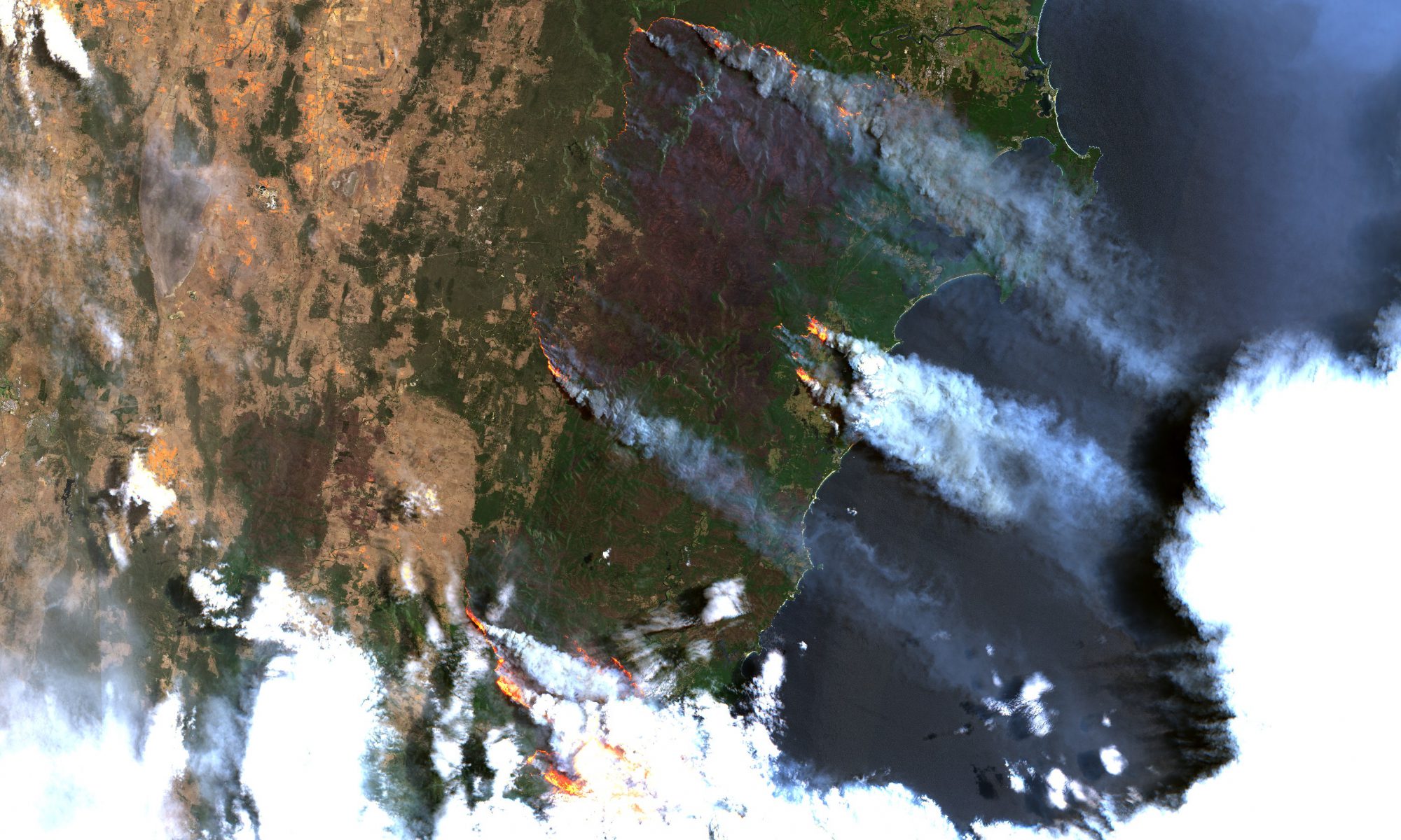
This year’s fire season in Australia is widely regarded as one of the most severe on record, causing detrimental damage to natural landscapes, wildlife, cities and critical infrastructure across the nation. Using data from NASA's MODIS satellites, we have detected an accumulated quarter of a million km2 affected by active bushfires, during the last two months, more than the total land mass of the United Kingdom.

We are saddened by the ferocious bushfires sweeping across Australia and devoted to continuing to deliver our impactful tools and services to assist authorities in responding and scaling efficiently and effectively during such disaster scenarios. Our satellite-based product portfolio is ideally positioned to provide rapid and cost-efficient information about fire risk, impact and movement, thus offering critical tools for fire response. As an example, our high-resolution soil moisture product can be applied nationwide to conduct largescale assessments of fire risk.

Driven by our passion for change and curiosity about innovative and integrated satellite-based solutions, we continue to explore avenues to support decision makers in making critical evidence-based decisions.

Satellites and offshore wind farms

SATELLITE-BASED SOLUTIONS TO SUPPORT THE OFFSHORE WIND INDUSTRY:

20 december 2019

Offshore wind has experienced tremendous growth in recent years as an attractive and clean energy alternative. However rigorous environmental legislation and a harsh and dynamic environment require thorough and meticulous planning as well as continuous operational monitoring of windmill installations and the dynamics of the surrounding water bodies.

The majority of the data and information needed to plan, construct and operate offshore wind farms is costly, time consuming and risky to collect, requiring rigorous field campaigns and expensive equipment.

Cost-effective and reliable solutions from space

Satellite-derived data products and services provide a powerful, low cost and efficient alternative to supplement or replace traditional monitoring solutions, by delivering up to date insight on the dynamics of the seabed and conditions of the environment around offshore wind farms. Our key offerings include satellite-based approaches to map and monitor shallow water bathymetry; aquatic vegetation; geomorphological dynamics and sedimentary variations around offshore wind installations. We also provide critical input data components to support offshore wind cable landfall assessments, such as coastal dynamics, digital terrain models and imagery for site planning.

Satellite image showing sand bars around OWF Horns Rev in the North Sea. Using this type of image data, it is possible to monitor and estimate the seabed dynamics, in this case movement rates of the large scale sand waves. © DHI, contains Copernicus Sentinel data.
Rasmus Borgstrøm (second from the right) and Torston Bondo (Far right) at WindEurope 2019

Growing interest in satellite-based products among major stakeholders

We have experienced an increased uptake and interest in our products and services, by stakeholders involved in the offshore wind industry, which was most recently solidified at the WindEurope Offshore conference in Copenhagen last month. The conference is a leading platform for peer to peer discussions with industry leaders and specialists and a unique opportunity to grasp the latest industry trends. We were represented by our Managing Director, Rasmus Borgstrøm and Business Development Manager, Torsten Bondo and their discussions with peers, potential clients and collaborators indicates a significant continued interest in our Earth Observation products, designed to support the monitoring needs of offshore wind operators.

Continued engagement with offshore industry partners and clients in 2020

As we are approaching the end of 2019, we are reflecting on an upbeat year where we have been excited to experience this attention and acceptance of our products and services by clients in the offshore wind industry, and we are looking forward to 2020 where we will continue to push our reliable and low-cost tools to support offshore wind farm operations.

See the video to below for further information and insight on how our products match the needs of clients and stakeholders in the offshore wind industry.

EOatDHI part of the DHI GROUP

gras@dhigroup.com
+45 4516 9100

Agern Alle 5,
2970 Hørsholm,
Denmark

CVR: 36466871

Mapping submerged aquatic vegetation

MAPPING SUBMERGED AQUATIC VEGETATION FROM SPACE:

18 DECEMBER 2019

Satellite based solutions to map and monitor the distribution of underwater vegetation dynamics in shallow water areas provides a cost-effective and efficient tool for consistent synoptic monitoring of large areas.

Delivering key insight on vegetation status and trends, satellite data provides a critical tool, enabling management authorities and decision-makers in making more effective decisions towards protecting and managing marine environments and resources.

Using high-resolution satellite data, novel machine learning techniques and advanced data processing, we have created the first-ever national overview of the spatial distribution of shallow-water submerged aquatic vegetation in Denmark.

The national map of submerged aquatic vegetation provides an important baseline on the current status of vegetation density in Danish territorial waters. Future efforts will aim to advance the baseline by making continuous assessments on year to year and intra annual variations in vegetation cover at national level.

With an established methodology and a scalable approach in place, satellite data can now be turned in to actionable data and information about the condition and status of submerged aquatic vegetation in shallow water areas, in any part of the world.

Thanks to the VELUX FOUNDATION for their generous grant, which has allowed us to reach this significant milestone.

Visit http://satlas.dk/marine-vegetation/ or click the button below to see the vegetation density map and learn more about satellite-derived aquatic vegetation mapping.

More information about coastal monitoring at DHI GRAS

EOatDHI part of the DHI GROUP

gras@dhigroup.com
+45 4516 9100

Agern Alle 5,
2970 Hørsholm,
Denmark

CVR: 36466871

Presenting our satellite-based CAP monitoring solution at MARS 2019

Presenting our satellite-based CAP monitoring solution at MARS 2019

27 NOVEMBER 2019

DHI GRAS is excited to participate in the 25th annual MARS conference this week in Prague, Czech Republic. The conference provides a platform for EU member states to discuss lessons learned and approaches to administer the Integrated Administration and Control System (IACS) under EU’s Common Agricultural Policy (CAP).

Represented by Kenneth Grogan and Lotte Nyborg, we will present a novel satellite-based approach to underpin the monitoring framework of national paying agencies under CAP2020+. Our solution provides a streamlined and highly accurate monitoring system to check if farmers report correctly on crop types and farm management practices according to the rules, procedures and eligibility requirements under the framework of EU’s CAP policy. The monitoring system has been developed, tested and operationally implemented by the Danish Agricultural Agency (DAA) and provides a streamlined solution to assess farmers applications according to CAP requirements, while at the same time reducing the amount of time spent on control visits.

In brief, our solution consists of:

1) a powerful back-end image processing chain for handling petabytes of satellite data
2) an advanced analytics toolbox for machine learning, deep learning and time series analysis
3) a sleek front-end web viewer for easy presentation of results and reporting.

Operational services are tailored to CAP monitoring needs, including crop type mapping, grassland activity monitoring, detecting harvest and tillage, and monitoring of catch crops.

We have been excited about contributing to shape the new agricultural monitoring practices in Europe and we congratulate the DAA as first movers in the EU to adopt a satellite-based solution to administer CAP monitoring. With our solution we have proved that satellite-services offer a highly accurate and cost-efficient alternative to existing in situ monitoring options and we are excited about our corporation with the DAA, to develop a robust and accurate CAP monitoring system, optimized for local conditions in order to achieve very high accuracies. We will be looking forward to meeting with national authorities and EU policy makers this week in Prague, to discuss how other countries can tap into the services offered by the monitoring system developed for the Danish authorities.

More information about agricultural monitoring at DHI GRAS

EOatDHI part of the DHI GROUP

gras@dhigroup.com
+45 4516 9100

Agern Alle 5,
2970 Hørsholm,
Denmark

CVR: 36466871

Eyes in the sky

EYES IN THE SKY:

06 SEPTEMBER 2019

Working with satellite imagery would be much easier if there were no clouds obstructing the view from satellites that orbit the earth far above the clouds.

Luckily, there are several clever ways to solve this problem. One way is to stitch satellite images of the same area together to create a composite.

Composites can be computed for any period of time, e.g. monthly, yearly, and for any area around the world.

Italy through the clouds


We have compiled a cloud-free composite of Italy, based on thousands of individual Sentinel 2 images from 2018, which can be accessed through our SATLAS site.

Image artefacts, such as orbit path and tile seamlines, cloud and cloud shadow interferences have been removed by our processing, creating a truly analysis-ready data layer, available at full Sentinel 2 resolution.

Use it for land cover classifications or for simple visualizations.

We have also previously produced monthly Sentinel 2 composites for crop type classification in Denmark and made seasonal composites for mangrove mapping in Myanmar.

EOatDHI part of the DHI GROUP

gras@dhigroup.com
+45 4516 9100

Agern Alle 5,
2970 Hørsholm,
Denmark

CVR: 36466871

Monitoring climate change from space

Monitoring climate change from space

09 AUGUST 2019

Yesterday saw the release of yet another disturbing report from the United Nations (UN) Intergovernmental Panel on Climate Change (IPPC), this time underpinning how critical human exploitation of land is a causal parameter of climate change.

The big takeaway is that while the UN has repeatably advocated for the reduction of the use of fossil fuels, this will not be enough to circumvent climate change and ensure a sustainable trajectory alone.

Unsustainable land use practices and a growing population has resulted in an ever-increasing emission of greenhouse gases into the atmosphere, exacerbating climate change, which consequently worsens the state of the planet – making it largely uninhabitable in many areas.

However, while the exploitation of land, and unsustainable land use practices is a big part of the problem, contributing almost 25% of global greenhouse emissions, it is also a major part of the solution.

In DHI GRAS we have a long history of almost 20 years, developing transformative applications based on satellite-data to provide critical information on the state of our planet, ecosystems and dynamics which can be used to mitigate the impacts of climate change and contribute to increase efficiency and effectiveness in our land use systems.

Using advanced machine learning algorithms and high-resolution data from the Sentinel satellites, we can measure and monitor a long range of parameters which can be used to optimize agricultural production systems and land use practices.

  • We can monitor and map land degradation and land degradation risk, which enables decision makers to take timely action to avoid, reduce and reverse land degradation which is critical to protect critical ecosystems which maintain biomass and mitigate climate change impacts.
  • We can monitor the productivity of production systems to provide key data and information which allows farmers and smallholders to optimize the use and application of fertilizers and pesticides to limit the release of CO2 and nitrous oxides.
  • Actual evapotranspiration can be measured at field level, by estimating transpiration from the vegetation and the evaporation from soil surfaces. As climate change is significantly reducing the quantity of renewable surface water and groundwater resources, this information is critical in order to optimize the amount of carbon assimilated as biomass in the crop, per water unit used in the production. We are currently applying this approach within an irrigation scheme in Uganda, under our AI4WATER project, aiming to reduce water consumption by 30%.


    Besides contributing with data and information relevant for the optimisation of land production systems, we deliver critical data which can be used to monitor the effects of climate change and mitigate impacts.

  • Based on historical and recent satellite imagery we can extract information about coastal dynamics, providing estimations of coastline changes (meters/year) caused by factors such as sand erosion/deposition, storm surges and sea level rise.
  • We can provide near real-time information on marine ecosystems including water quality, which provides key information allowing for proactive management of water incidents, such as algal blooms caused by release of excess nutrients from agriculture, red tides or sediment plumes.
  • We can proactively monitor flood risks and map the extent of flooding events, which is critical for efficient flood risk management and land use planning.
  • We can monitor temperature changes, i.e. to identify urban heat islands, and we can map impervious surfaces which can be used by city planners and public authorities to manage and plan green spaces and manage water runoff to prevent flooding, erosion and water pollution.

    So, while the IPCC concludes that the planet is on an unsustainable trajectory, we believe we are part of the solution – by bridging critical earth observation data and relevant stakeholders, we can enable decision makers to take confirmative actions to respond to the severity of climate change.

More information about climate related services at DHI GRAS

EOatDHI part of the DHI GROUP

gras@dhigroup.com
+45 4516 9100

Agern Alle 5,
2970 Hørsholm,
Denmark

CVR: 36466871

Preparing national paying agencies for CAP2020+

Preparing national paying agencies for CAP2020+:

02 July 2019

We are very pleased to announce that we will be supporting the Danish Agricultural Agency (DAA) in the coming years with a “first of its kind” national monitoring system under the CAP 2020+.

Through our past projects with the DAA, we have developed in-house data processing systems that are tailor-made for these two new project wins using satellite image analyses for agricultural monitoring, where DHI GRAS is the sole lead for the first project and will be joining forces with NEO BV Netherlands for the second one.

Our processing systems are well capable of handling the large amounts of satellite data and our experienced team is ready to deliver cutting-edge remote sensing services for a national-scale agricultural monitoring system.

DHI GRAS has since its beginning in 2000 kept at the forefront of Earth Observation (EO) technology, and continuously tested and developed new methods to enhance the uptake of EO-based services.

We are therefore excited to be part of shaping the new monitoring practices for the DAA and for other countries to tap into the experience and services developed during the projects.


More information about agricultural monitoring at DHI GRAS

EOatDHI part of the DHI GROUP

gras@dhigroup.com
+45 4516 9100

Agern Alle 5,
2970 Hørsholm,
Denmark

CVR: 36466871

Supporting the Copernicus Land Team at the European Environment Agency

Supporting the Copernicus Land Team at the European Environmental Agency:

28 June 2019

In continuation of our excellent collaboration on previous activities with the European Environment Agency (EEA), DHI GRAS is providing on-site consultancy services for the Copernicus Land Team at the centrally-located offices of the EEA in the heart of Copenhagen.

We are supporting the Copernicus Land Team with on-going Pan-European mapping activities and advising on technical specifications including recommendations on geospatial data and systems integration, such as the integration of Copernicus Land Monitoring Service (CLMS) data in DIAS (Data and Information Access Services) platforms.

We are also producing seamless high resolution image mosaics of 39 European countries (EEA39), which are both geometrically and radiometrically corrected.

Copernicus is the European Union's Earth Observation Programme, looking at our planet to provide users in the field of environment and other terrestrial applications with information based on space data in six thematic areas: land, marine, atmosphere, climate change, emergency management and security.


For more information about our previous activities with the EEA and Copernicus Land Monitoring Service

Saving water with satellites

Saving water with satellites:

17 June 2019

A new system is being considered for inclusion in the EU’s Earth Observation programme, Copernicus, to estimate water-use by plants evapotranspiration and to improve crop water-use productivity.

The Land Surface Temperature Monitoring (LSTM) mission will be able to identify the temperatures of individual fields and would be more than 400 times as detailed as what is delivered by the current Sentinel satellite land surface temperature sensors.

The increased resolution and precision of LSTM will enable specialists to calculate in real time how much water different plants require in different areas, and how often those plants need to be irrigated. It could also be used to help predict drought conditions.

The LSTM mission will complement the existing family of Copernicus satellites, sentinels, for observing the land and coastal areas, and will hopefully become an operational spacecraft within the next decade.

Our senior remote sensing specialist, Radoslaw Guzinski, is one of the authors behind the Mission Requirements Document, and we will follow the activities closely in the coming years.


In the meantime, we are working on innovative methods and tools to estimate field-scale plant water-use with the data coming from existing Copernicus satellites. See link below for project website.

EOatDHI part of the DHI GROUP

gras@dhigroup.com
+45 4516 9100

Agern Alle 5,
2970 Hørsholm,
Denmark

CVR: 36466871

National Geographic Explorer Festival

National Geographic Explorer Festival:

13 June 2019

As part of our AI4Earth grant funded by Microsoft and National Geographic Society, Torsten Bondo is in Washington DC for the annual National Geographic Explorer Festival.

It is an extremely exciting and inspiring venue featuring marine biologists, glaciologists, mountaineers, photographers and many other people with an interest in natural sciences.

Torsten Bondo is there to discuss our Uganda project using AI and satellites to assist agricultural irrigation schemes and safeguard the scarce water resources. A method that has the potential to work on a global scale.

Berlingske Media has published an article about the project [in Danish].

EOatDHI part of the DHI GROUP

gras@dhigroup.com
+45 4516 9100

Agern Alle 5,
2970 Hørsholm,
Denmark

CVR: 36466871