MCSAV – Satellite‑based mapping and monitoring of coastal ecosystems at scale (Malaysia)

Why is it important?

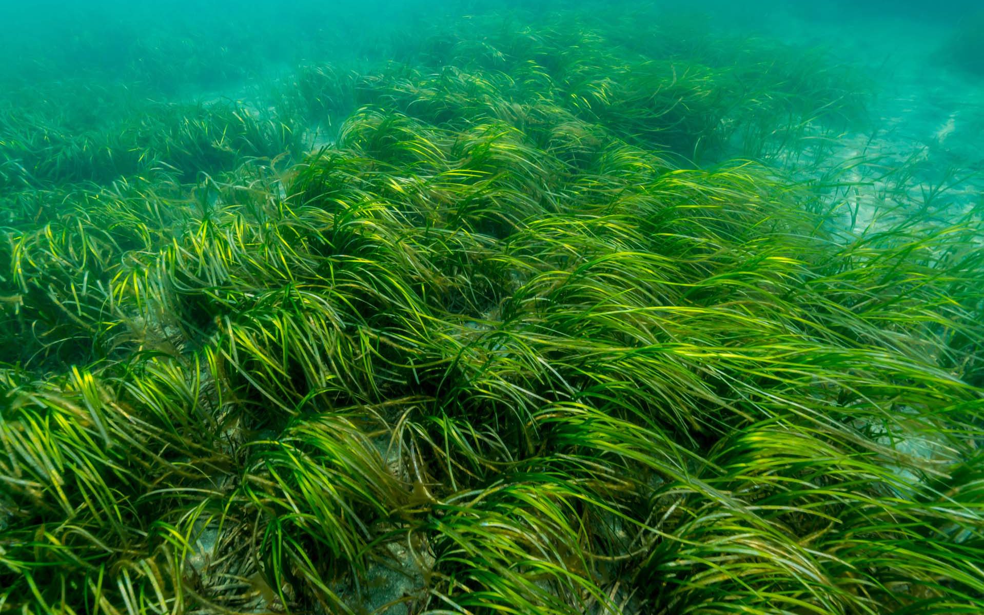
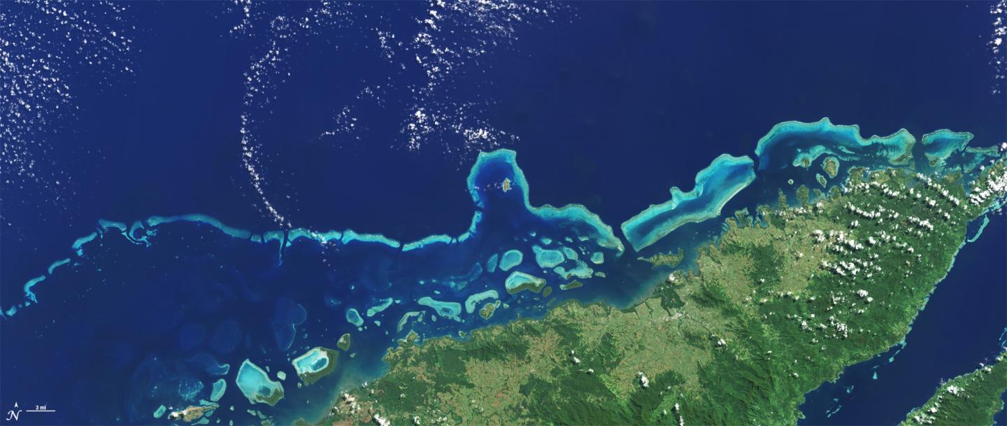
Reliable information on the distribution and condition of coastal and marine ecosystems is essential for sustainable management of marine resources. Habitats such as mangroves, coral reefs, and submerged aquatic vegetation play a critical role in biodiversity, fisheries, and coastal protection, yet they are often difficult to monitor consistently using traditional field‑based surveys alone. In tropical coastal regions, monitoring is further challenged by large geographic extents, limited access, and high costs, which can result in fragmented or outdated information. Satellite Earth observation offers a way to overcome these limitations by providing regular, large‑area coverage that can be repeated over time. Mangroves, Corals, Submerged Aquatic Vegetation (MCSAV) addresses this gap by using satellite data to support cost‑effective, scalable, and repeatable monitoring of coastal ecosystems. By making satellite‑derived information accessible through a web‑based platform, the project supports evidence‑based marine management, helps inform area‑based protection and planning, and contributes to more sustainable use of coastal and marine resources.

Project highlights:

MCSAV delivers regular, large‑area coastal habitat maps using Copernicus Sentinel‑2 imagery, enabling consistent mapping of mangroves, coral/rubble, sand, and submerged aquatic vegetation across extensive tropical coastal zones that cannot be effectively covered by field surveys alone.
A pre‑trained deep‑learning model forms the backbone of the system, enabling automated habitat classification. A built‑in “human‑in‑the‑loop” workflow allows local experts and communities to refine results using field observations, improving accuracy while retaining ease of use for non‑specialist users.
The cloud‑based platform provides an interactive environment where users can generate, visualise, validate, and export habitat maps in standard GIS formats. This supports monitoring of change over time and practical application in conservation planning, MPA management, and sustainable use of coastal resources.

In more detail..

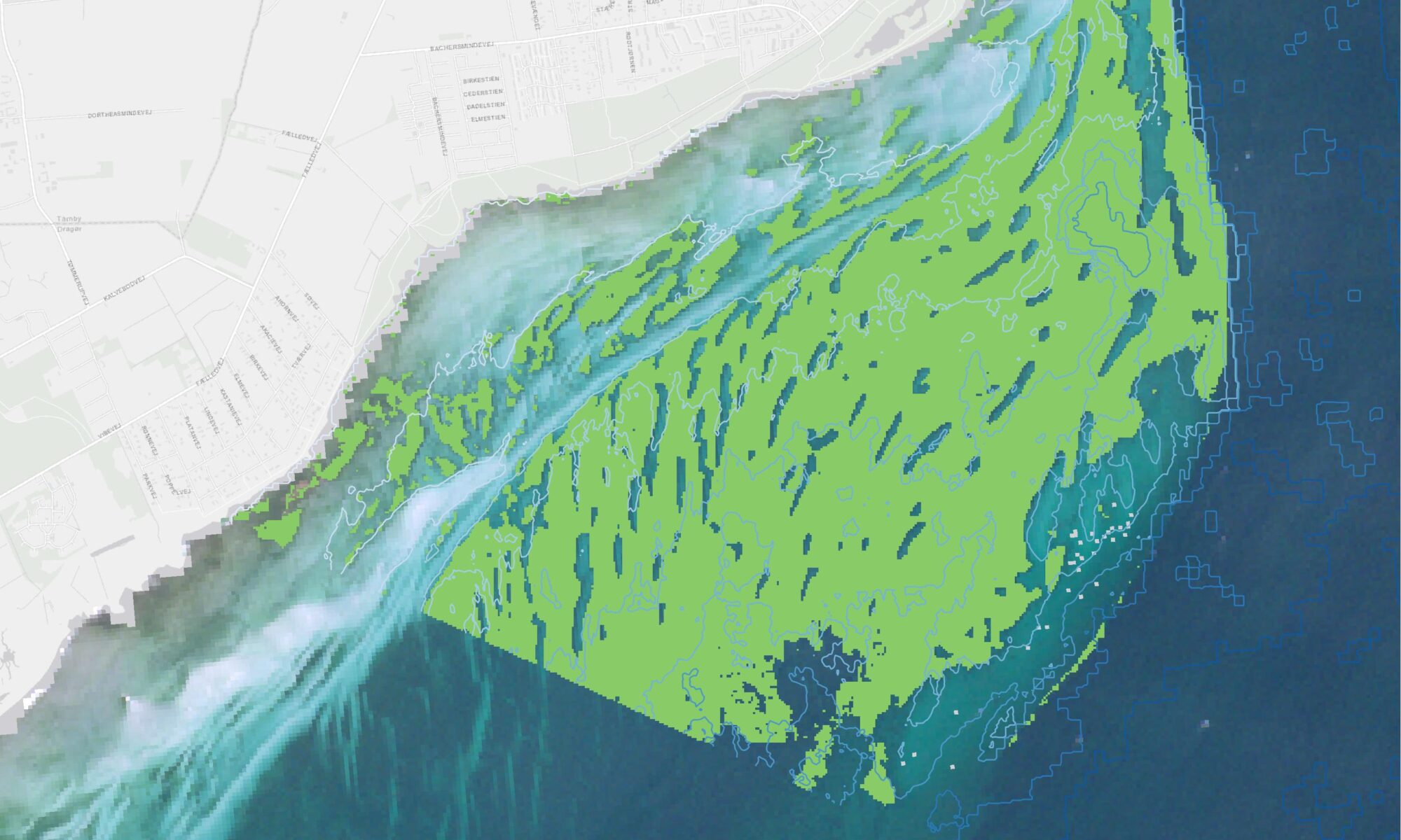
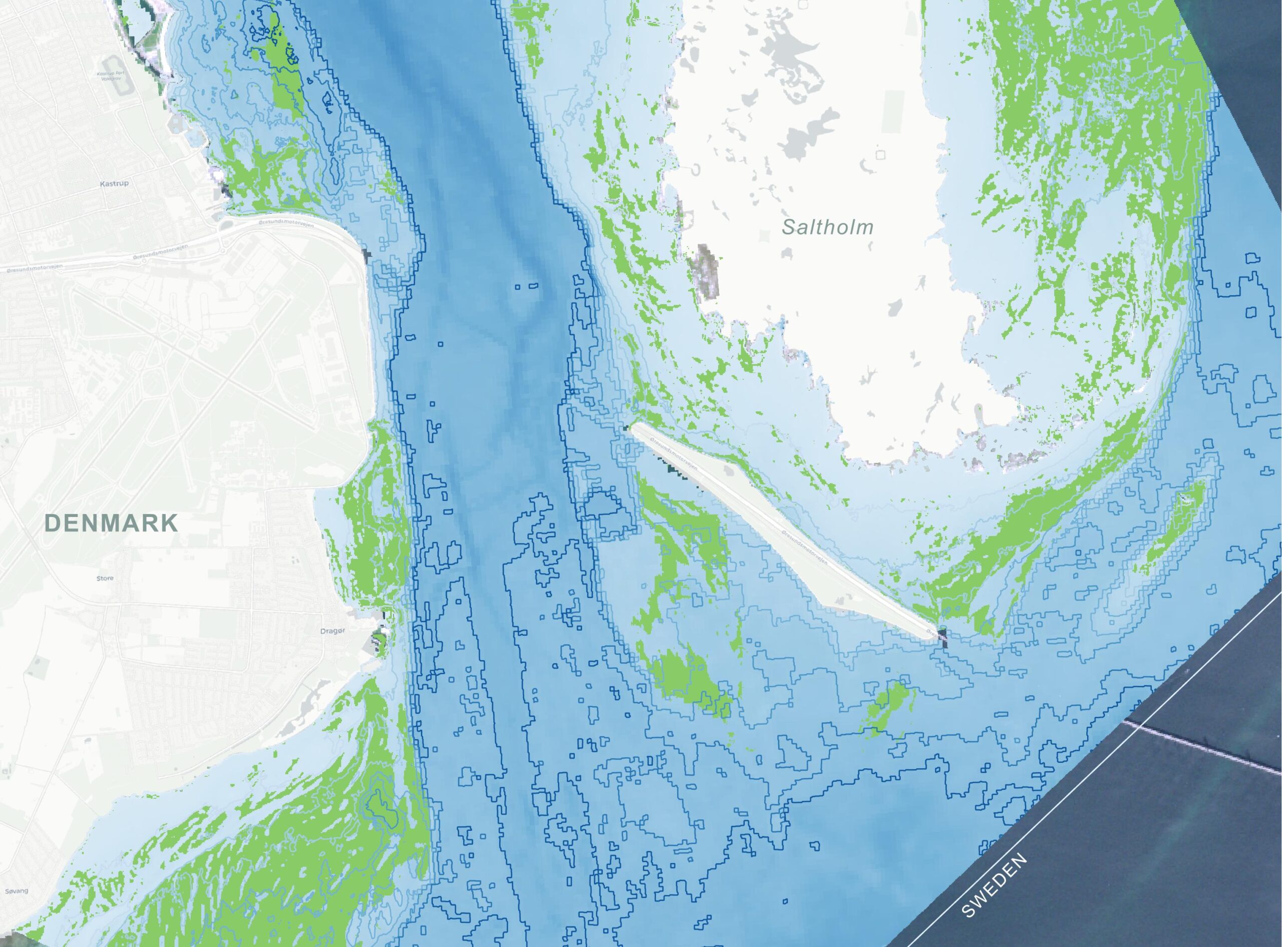
Mangroves, Corals, Submerged Aquatic Vegetation (MCSAV) aims to make large‑scale coastal and marine ecosystem monitoring possible using satellite Earth observation. Important marine habitats such as mangroves, coral reefs, and submerged aquatic vegetation are often difficult to survey consistently using field‑based methods alone, especially in regions where access is limited and monitoring resources are constrained.

The project uses data from the Copernicus Sentinel‑2 satellites, which provide frequent, freely available imagery suitable for mapping shallow coastal environments across large areas. Satellite images are analysed using automated image analysis and machine‑learning techniques, making it possible to generate repeatable habitat maps and to monitor changes over time.

MCSAV was developed by DHI together with partners and collaborators, including Reef Check Malaysia and Stop Fish Bombing Malaysia, as part of the 3rd Call of the UNDP Ocean Innovation Challenge.

The project combines technical Earth‑observation expertise with local knowledge to ensure that the resulting information is both scientifically robust and relevant for practical use.

A key feature of MCSAV is its delivery through a web‑based platform designed for a broad range of users, including authorities, planners, NGOs, and local stakeholders. The platform allows users to explore habitat maps, visualise changes over time, and use the results as input to marine management, conservation planning, and area‑based protection initiatives.< Overall, MCSAV demonstrates how satellite data can be transformed into accessible, decision‑ready information, supporting more effective marine ecosystem management and contributing to sustainable use of coastal and marine resources in line with broader blue‑economy and conservation objectives.

UNDP Ocean Innovation Challenge

DHI was selected as one of four innovators in the third Ocean Innovation Challenge (OIC) of the United Nations Development Programme (UNDP) to receive financial and incubator support.

Earth Observation Centre of Excellence part of the DHI GROUP

info@dhigroup.com
+45 4516 9200

Agern Alle 5,
2970 Hørsholm,
Denmark

CVR: 36466871

Integrated Marine Monitoring Denmark – areal distribution of submerged aquatic vegetation

Why is it important?

Danish marine environmental monitoring has traditionally relied heavily on ship based data collection, which is costly and provides limited temporal and spatial coverage. This makes it challenging to assess ecological status consistently and efficiently across Denmark’s marine waters, particularly in a policy context where reporting obligations require robust, repeatable, and spatially explicit assessments. On behalf of the Danish Agency for Green Transition and Aquatic Environment, DHI is establishing an integrated monitoring approach that combines modelling, Earth observation (EO) and survey data. This integrated marine monitoring (IMM) framework provides a stronger, more scalable foundation for national ecological status assessment, enabling continuous monitoring, improved spatial coverage, and support for reporting under European environmental directives. One aspect of IMM focuses on efficient, repeatable mapping of submerged aquatic vegetation (SAV) at scale.

Project highlights:

Use of free Copernicus Sentinel‑2 imagery to provide nationwide, high‑resolution (10 × 10 m) mapping of submerged vegetation, including seagrasses and other marine macrophytes. Frequent satellite revisits enable consistent coverage of all Danish coastal waters, overcoming the spatial and temporal limitations of traditional surveys.

The system applies deep‑learning‑based classification models within a largely automated processing chain, transforming satellite imagery into ready‑to‑use habitat maps. Automation reduces manual workload, increases objectivity, and enables regular updates needed for national‑scale monitoring and long‑term trend analysis.

EO‑derived marine vegetation maps from IMM Denmark are input to other environmental assessment frameworks, where they are combined with other sources of information and in the longer term support digital twins of the marine environment.

In more detail..

IMM SAV is developed as part of the broader national marine monitoring project led by DHI. The project delivers a repeatable, scalable method for mapping the spatial extent of submerged aquatic vegetation, including rooted plants such as eelgrass and macroalgae.

The system is built on Copernicus Sentinel‑2 imagery, offering 10 × 10 m spatial resolution, frequent revisit times, and a consistent historical archive dating back to 2016. This enables nationwide coverage and supports both retrospective analysis and continuous monitoring as new satellite data become available. For selected areas, the satellite‑based approach is complemented by aerial imagery, providing higher spatial detail where needed while acknowledging its more limited temporal availability.

Mapping is performed using machine‑learning and transfer‑learning techniques, with models trained specifically for local coastal conditions. A growing central training dataset allows model performance to improve over time, while a multi‑temporal analysis approach increases robustness by combining information from multiple observations instead of relying on single images.

Beyond mapping, the project supports the development of a new area‑based indicator for submerged aquatic vegetation, designed to complement existing depth‑based indicators and improve assessment in shallow coastal waters. The indicator framework is aligned with regulatory requirements and designed to respond to key environmental pressures, while remaining robust to variation in observation timing and data availability.

Strong emphasis is placed on quality assurance, validation, and documentation, ensuring that satellite‑derived vegetation products can be used operationally and integrated into routine monitoring, assessment, and reporting workflows. As such, SAV Denmark represents a mature application of Earth observation, moving beyond experimental mapping towards a stable, long‑term monitoring capability.

Danish Agency for Green Transition and Aquatic Environment

The project is funded by the Danish Agency for Green Transition and Aquatic Environment.

Earth Observation Centre of Excellence part of the DHI GROUP

info@dhigroup.com
+45 4516 9200

Agern Alle 5,
2970 Hørsholm,
Denmark

CVR: 36466871

Marine vegetation mapping in Sweden

Why is it important?

According to the EU Habitat directive and the Marine Strategy Framework Directive, member states are required to map, monitor and evaluate changes in the quality and areal distribution of different marine habitats and biotopes. Submerged aquatic vegetation (SAV), in particular eelgrass, is one of the key indicators of ecological status and environmental state of water bodies, and therefore widely used in reporting related to these directives.

Project highlights:

Copernicus Sentinel-2 imagery, novel machine learning techniques and advanced data processing to create the first spatial overview of the distribution of SAV at national scale in Sweden.

A cloud-based web-application for Sentinel-2 based SAV mapping without prior specialist knowledge Input.

A training dataset constructed with more than 30 000 manually drawn polygons to build a robust machine learning model and predict nationwide SAV.

In more detail..

In 2020 we embarked on a project together with the Swedish regional and national authorities, to combine Copernicus Sentinel-2 satellite imagery, novel machine learning techniques and advanced data processing to create the first spatial overview of the distribution of SAV at national scale in Sweden. A training dataset constructed with more than 30 000 manually labelled polygons was used to build the classification model, with which more than 3800 km2 of the underwater habitats, of the entire shallow coastal zone of Sweden, was mapped. Applying Sentinel-2 imagery from 2019-2020, the resulting classification, in 10-meter spatial resolution, provides nationwide coverage and detailed insight into the status of aquatic vegetation in the shallow water areas of Sweden.

Moreover, in close coordination with the key stakeholders, we have developed a cloud-based web-application that enables individual counties along the Swedish coast to perform their own SAV mapping without prior specialist knowledge. This ties into a long-term objective of the counties in Sweden to easier comply with national monitoring and reporting requirements, and thereby for Sweden to better comply with international requirements at EU level.

The project outcome and methodologies are further described in the following peer-reviewed article:

Huber, Silvia. et al. (2021), Novel approach to large-scale monitoring of submerged aquatic vegetation: A nationwide example from Sweden. Integrated Environmental Assessment and Management.

Länsstyrelsen Västerbotten

Länsstyrelsen Västerbotten, on behalf of the Swedish Agency for Marine and Water Management.

Earth Observation Centre of Excellence part of the DHI GROUP

info@dhigroup.com
+45 4516 9200

Agern Alle 5,
2970 Hørsholm,
Denmark

CVR: 36466871

Mapping submerged aquatic vegetation

MAPPING SUBMERGED AQUATIC VEGETATION FROM SPACE:

18 DECEMBER 2019

Satellite based solutions to map and monitor the distribution of underwater vegetation dynamics in shallow water areas provides a cost-effective and efficient tool for consistent synoptic monitoring of large areas.

Delivering key insight on vegetation status and trends, satellite data provides a critical tool, enabling management authorities and decision-makers in making more effective decisions towards protecting and managing marine environments and resources.

Using high-resolution satellite data, novel machine learning techniques and advanced data processing, we have created the first-ever national overview of the spatial distribution of shallow-water submerged aquatic vegetation in Denmark.

The national map of submerged aquatic vegetation provides an important baseline on the current status of vegetation density in Danish territorial waters. Future efforts will aim to advance the baseline by making continuous assessments on year to year and intra annual variations in vegetation cover at national level.

With an established methodology and a scalable approach in place, satellite data can now be turned in to actionable data and information about the condition and status of submerged aquatic vegetation in shallow water areas, in any part of the world.

Thanks to the VELUX FOUNDATION for their generous grant, which has allowed us to reach this significant milestone.

Visit http://satlas.dk/marine-vegetation/ or click the button below to see the vegetation density map and learn more about satellite-derived aquatic vegetation mapping.

More information about coastal monitoring at DHI GRAS

Earth Observation Centre of Excellence part of the DHI GROUP

info@dhigroup.com
+45 4516 9200

Agern Alle 5,
2970 Hørsholm,
Denmark

CVR: 36466871

Mapping submerged coastal vegetation

submerged coastal vegetation

Why is it important?

Marine habitats are important regions for life in the coastal zone. It is one of the key indicators of ecological status and environmental state of water bodies and therefore widely used in reporting related to e.g. the EU Water Framework Directive and the Birds Directive and as input in Environmental Impact Assessments (EIA’s).

With this project a first-ever complete baseline of the spatial distribution will be created which will allow for a future assessment of any changes in submerged coastal vegetation.

Project highlights:

Using satellite data, machine learning and radiative transfer modelling to accurately extract detailed information about marine habitats

Integration of various data sources (in-situ, satellite and models) to provide a more complete and holistic description of the coastal zone

Project outputs will be made openly and freely available providing a baseline for future assessments of changes in the ecological status on national to local scale

In more detail..

DHI GRAS has been awarded a grant from the VELUX FOUNDATION to conduct a first-ever nationwide mapping of the submerged coastal vegetation (eelgrass and macroalgae) in Denmark. Based on advanced radiative transfer modelling and machine learning techniques, optical satellite data is used to create a 10 m national map of these important coastal habitats. The project runs from 2018 to 2019.

The results will be made publicly available to stakeholders active in the coastal zone, including authorities, coastal planners, engineering companies and environmental consultants.

The free and open access approach is part of an active wish from the VELUX FOUNDATION and "DHI GRAS to expand our knowledge of the coastal zone processes and environmental state.

These are the core elements of the project:

In 2018, VELUX FONDEN granted approx. EUR 35 million. ​VELUX FONDEN (a part of THE VELUX FOUNDATIONS) is a philanthropic foundation that supports scientific, cultural, social and environmental purposes.

Furthermore, the foundation supports projects relating to active senior citizens and research in gerontology and ophthalmology. All grant areas share the purpose of promoting the democratic society of Denmark on an informed, inclusive and sustainable basis.

Earth Observation Centre of Excellence part of the DHI GROUP

info@dhigroup.com
+45 4516 9200

Agern Alle 5,
2970 Hørsholm,
Denmark

CVR: 36466871