Integrated Marine Monitoring Denmark – areal distribution of submerged aquatic vegetation
Supporting ecological status assessment through integrated observations and modelling
Why is it important?
Danish marine environmental monitoring has traditionally relied heavily on ship based data collection, which is costly and provides limited temporal and spatial coverage. This makes it challenging to assess ecological status consistently and efficiently across Denmark’s marine waters, particularly in a policy context where reporting obligations require robust, repeatable, and spatially explicit assessments. On behalf of the Danish Agency for Green Transition and Aquatic Environment, DHI is establishing an integrated monitoring approach that combines modelling, Earth observation (EO) and survey data. This integrated marine monitoring (IMM) framework provides a stronger, more scalable foundation for national ecological status assessment, enabling continuous monitoring, improved spatial coverage, and support for reporting under European environmental directives. One aspect of IMM focuses on efficient, repeatable mapping of submerged aquatic vegetation (SAV) at scale.
Project highlights:
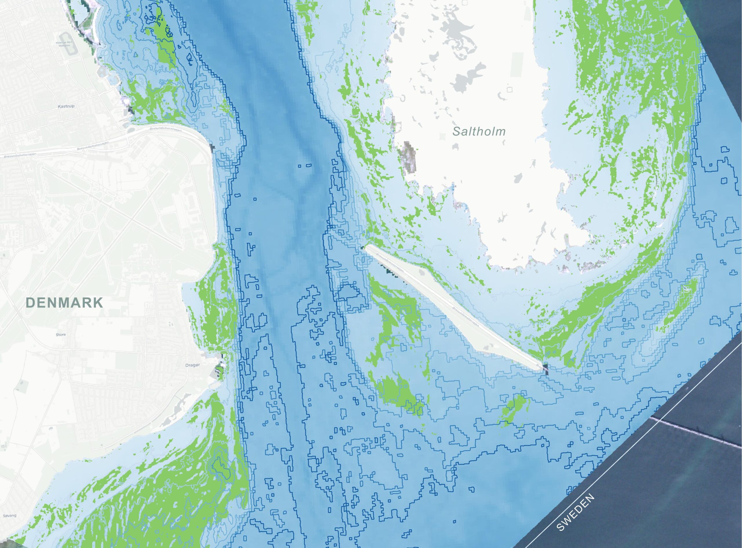
Use of free Copernicus Sentinel‑2 imagery to provide nationwide, high‑resolution (10 × 10 m) mapping of submerged vegetation, including seagrasses and other marine macrophytes. Frequent satellite revisits enable consistent coverage of all Danish coastal waters, overcoming the spatial and temporal limitations of traditional surveys.
EO‑derived marine vegetation maps from IMM Denmark are input to other environmental assessment frameworks, where they are combined with other sources of information and in the longer term support digital twins of the marine environment.
In more detail..
IMM SAV is developed as part of the broader national marine monitoring project led by DHI. The project delivers a repeatable, scalable method for mapping the spatial extent of submerged aquatic vegetation, including rooted plants such as eelgrass and macroalgae.
The system is built on Copernicus Sentinel‑2 imagery, offering 10 × 10 m spatial resolution, frequent revisit times, and a consistent historical archive dating back to 2016. This enables nationwide coverage and supports both retrospective analysis and continuous monitoring as new satellite data become available. For selected areas, the satellite‑based approach is complemented by aerial imagery, providing higher spatial detail where needed while acknowledging its more limited temporal availability.
Mapping is performed using machine‑learning and transfer‑learning techniques, with models trained specifically for local coastal conditions. A growing central training dataset allows model performance to improve over time, while a multi‑temporal analysis approach increases robustness by combining information from multiple observations instead of relying on single images.
Beyond mapping, the project supports the development of a new area‑based indicator for submerged aquatic vegetation, designed to complement existing depth‑based indicators and improve assessment in shallow coastal waters. The indicator framework is aligned with regulatory requirements and designed to respond to key environmental pressures, while remaining robust to variation in observation timing and data availability.
Strong emphasis is placed on quality assurance, validation, and documentation, ensuring that satellite‑derived vegetation products can be used operationally and integrated into routine monitoring, assessment, and reporting workflows. As such, SAV Denmark represents a mature application of Earth observation, moving beyond experimental mapping towards a stable, long‑term monitoring capability.