VeriCAP

Why is it important?

Every year, paying agencies across the EU performs thousands of on-site control visits to field parcels across nations, to check if farmers report correctly on crop types and farm management practices according to the rules, procedures and eligibility requirements under the framework of EU’s Common Agricultural Policy (CAP). A single control visit is often not sufficient to cover the different agricultural activities over the year, thus increasing demands of time and resources for both paying agencies and applicants.

How can it help?

In line with the requirements of the 2020 CAP reform, aiming to modernize and simplify CAP requirements, satellite-based CAP monitoring solutions are increasingly being adopted to address the existing monitoring burden, as a cost efficient and effective solution to monitor crops and activities on field parcels at national level.

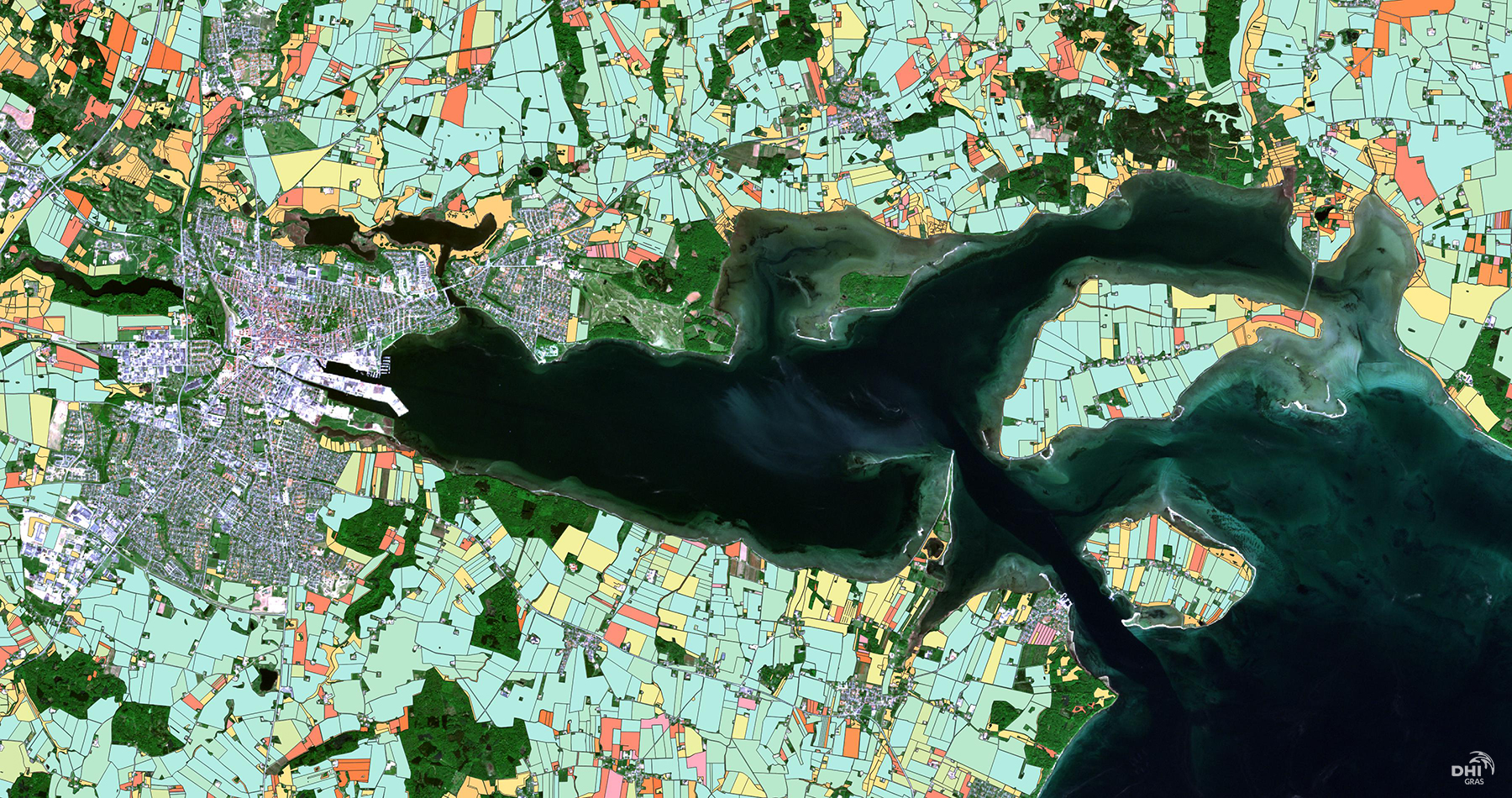
VeriCAP provides a streamlined and accurate check by monitoring (CbM) solution to monitor crop types and farm management practices according to CAP rules and requirements. VeriCAP has been developed, tested and operationally implemented at national level by the Danish Agricultural Agency (DAA), as an end-to-end CAP monitoring solution, enabling them to harmonise existing monitoring frameworks, reduce the need for field visits and ultimately, increase effectiveness and reduce costs.

VeriCAP provides an integrated, scaleable and flexible solution that serves the specific priorities and local conditions of each EU member state or regional authority.

What you get!

A powerful back-end image processing chain for handling petabytes of satellite data to validate parcel boundaries,  map and monitor crop types, grassland activity, harvest and ploughing and catch crops.

An advanced analytics toolbox for machine learning, deep learning and time series analysis and a sleek front-end web viewer for easy presentation of results and reporting.

A tailored and integrated solution conforming to local conditions and specific needs and requirements of the client. 

Typical customers?

National and regional paying agencies in the EU with a need to increase effectiveness in CAP monitoring in line with the requirements of the CAP2020 reform

Specifications

  • Six core CAP monitoring services:
      1. Parcel boundary validation
      2. Crop classification
      3. Grassland activity
      4. Ploughing
      5. Harvest
      6. Catch crops
  • Parcel level analysis as well as subparcel /pixelbased analysis and products – making best use of Sentinel 1/2, Landsat and commercial data sources, such as Planet data.

  • Markers updated on a daily basis and solution is operational on national scale
  • A sleek and customized interactive web viewer for easy data visualization, interpretation and reporting
  • The solution is available for any country or regional authority in the EU and flexible to be implemented based on the specific needs,  regulations, and regional conditions 

More information

Contact Lotte Nyborg (ln@dhigroup.com) for more information on VeriCAP.

EOatDHI part of the DHI GROUP

gras@dhigroup.com
+45 4516 9100

Agern Alle 5,
2970 Hørsholm,
Denmark

CVR: 36466871

Join us for the ET4FAO Final Virtual Workshop

Join us for the ET4FAO Final Virtual Workshop

17 MAY 2021

ET4FAO final workshop, May 25 from 13:00 – 15:00 CET

Agenda:

13:00-13:10        Introduction, Radoslaw Guzinski, DHI GRAS

13:10-13:20        WaPOR portal and ET products, Livia Peiser, FAO

13:20-14:00        ET4FAO methods, Radoslaw Guzinski, DHI GRAS

14:00-14:30        ET maps inspection and validation, Hector Nieto, Complutig

14:30-14:55        Copernicus-based ET, Benjamin Koetz, ESA

14:55-15:00        Conclusions, Radoslaw Guzinski, DHI GRAS

Growing populations and associated increase in food production, together with shifting weather patterns due to climate change, are putting increased pressure on fresh water resources. A large majority of worldwide fresh water withdrawals are for agricultural use and specifically for crop irrigation. For example, in the Mediterranean region the agricultural water use can comprise up to 70% of withdrawn fresh water. Therefore, the use of modern technology to improve crop water use efficiency at field, as well as at regional and national levels, is an urgent necessity.

Satellite-based Earth Observation (EO) is an example of such a technology which could have significant impact on agricultural water use. In particular, a combination of thermal and optical observations can be used to estimate the actual evaporation (E) from the soil and transpiration (T) from the vegetation, which taken together are called evapotranspiration (ET) and represent the actual flux of water from the land surface into the atmosphere.

By utilizing the knowledge of ET at appropriate spatial and temporal scales, it is possible to better allocate water used for irrigation, thus increasing the sustainability of agriculture and hence ensuring the livelihoods of farmers in a changing climate. At the same time, the EO-derived ET maps can be used for national-scale water use accounting and water productivity monitoring, which are required reporting on Sustainable Development Goal indicator 6.4.1, and can be used to plan and execute national water strategies.

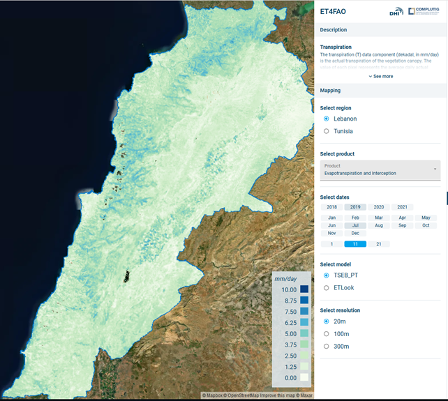
The Copernicus Sentinel satellite constellation holds all the required spatial, temporal and spectral properties required for mapping of ET at different spatial scales. As part of our ESA funded project “Increasing crop water use efficiency at multiple scales using sentinel evapotranspiration – ET4FAO”, we have evaluated the suitability of using Copernicus data (in particular Sentinel-2 and Sentinel-3 satellite observations and ERA5 meteorological data) and methods developed in the “Sen-ET project” to produce national-scale ET maps which are consistent at multiple spatial resolutions (20 m to 300 m). Such ET data will be critical to consistently map and monitor water use efficiency from field to national levels and could be used during the evolution of FAO’s WaPOR portal.

Under the framework of ET4FAO, we are hosting a final workshop on May 25, from 13:00 – 15:00 CET, entitled “Consistent Estimation of Evapotranspiration at Multiple Spatial Scales Using Copernicus Data”, together with ESA and our partners in FAO and COMPLUTIG, where we will present the outputs and lessons learned.

This workshop will outline the methods developed during the project, showcase Copernicus based ET maps which are available here, and present validation against field measurements and comparison with WaPOR products. The future potential of Copernicus-based ET products will be also discussed.

The workshop is targeted to experts in remote sensing in the field of agriculture and hydrology.

SAR4SAR – Enhancing Arctic Search and Rescue operations using radar satellite imagery

Why is it important?

Maritime activity across the Arctic is increasing together with increased economic activity and geopolitical awareness in the region. The increased traffic is mainly due to fishing, bulk carrier traffic, mineral exploration activities, cruise tourism but also an increasing need for sovereignty enforcement capabilities. Adding to this, local traffic, of which smaller fishing vessels, recreational boating, and local tourist operators are the main purposes.

Consequently, supporting safety at sea, safeguarding national sovereignty as well as offering support to the civil society, efficient and capable naval and first responding capacities are being important as ever before to Arctic societies and nations. As examples of this, in Greenland alone, every year more than 50 search-and-rescue operations take place, where smaller boats and dinghies (dark-vessels) are involved.

Also, cruise tourism in the Arctic is expected, post-COVID-19, to attract even more tourists. These cruise ships often carry well over 500 passengers and in the event of an emergency situation where life rafts have to be used, there will be a pronounced need to provide an overview of the positions of these rafts, as they can quickly spread over large areas, due to rough environmental conditions.

All in all, the increased Arctic maritime traffic constitutes an increasing safety risk element, which is why increased capabilities concerning the location of small maritime objects and dark-vessel detection are required.

Project highlights:

Exploring how Danish companies within the marine, security and defense sectors can contribute with solutions increasing the visibility of small maritime objects in radar satellite images.

Feasibility live tests of equipment and tech solutions under Arctic conditions, securing Arctic-fit solutions.

Bridging scientific and industry knowledge and experience, safeguarding scientific and industry excellence and requirements.

In more detail..

Maritime activity across the Arctic is increasing together with increased economic activity and geopolitical awareness in the region. Supporting safety at sea, safeguarding national sovereignty as well as offering support to the civil society, efficient and capable naval and first responding capacities are being important as ever before to Arctic societies and nations and a clear need for enhanced navigational situational awareness exists.

Adding to this, communication opportunities in the Arctic are often limited outside the populated areas, due to vast distances and lack of communication infrastructure. In the case of dark-vessel-detection, e.g. for search-and-rescue operations, navies and first responders often have to search vast areas with little opportunity to efficiently identify the exact location of those in need in the often harsh environmental conditions.

Satellite-based decision support allows among other things efficient object identification within large areas. However, satellite-based object identification in the Arctic is challenged by a number of factors, including cloud cover, limited sunlight much of the year as well as large geographical areas, and widespread lack of up-to-date coastal information. SAR (Synthetic Aperture Radar) based sensors utilize microwave reflection against a given surface and can thus operate independently of cloud cover and light conditions, which is why SAR-based satellite data is particularly suitable under Arctic conditions.

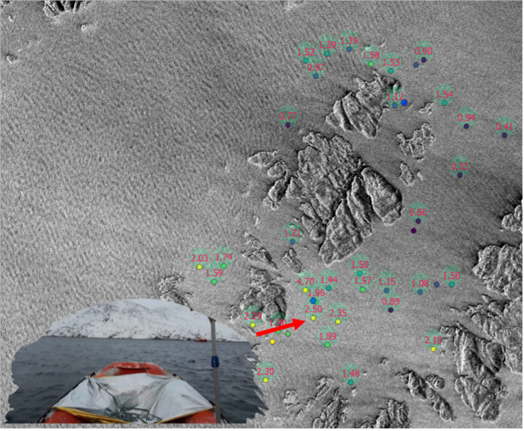
The challenge of object identification in connection with search-and-rescue operations using SAR satellite data is that publicly available, e.g., Sentinel 1 from the European Space Agency (ESA), does not offer a sufficiently high spatial resolution to determine objects smaller than about 20m. In addition, the temporal resolution is also too low (3-5 days return visit time) to provide near-real-time data.

Due to recent and substantial expansion in commercial satellite constellation capabilities, it is possible to obtain high temporal and spatial resolution radar satellite data. However, detecting small maritime objects and dark vessels remains a challenging task and therefore SAR4SAR will explore how these challenges can be overcome by combining research and industry knowledge and tested in a live environment.

Center for Defence, Space & Security:

The Center for Defence, Space & Security (CenSec) is the prime Danish cluster for small and medium-sized enterprises specializing in high tech industries like defence, homeland security, space, aerospace, railway and maritime.

CenSec was founded in 2004 and established in 2007 as an industrial cluster. In 2018, CenSec was approved by the Danish Ministry of Higher Education and Science to also become a national Innovation Network for Security (Inno-Sec)

Related items

AI4ALERT

Developing novel geointelligence solutions to underpin security and defence related needs and requirements

Read More

Global Seas

Delivering earth observation enriched high-quality metocean data to enhance fuel efficiency in the shipping industry. . . .

Read More

EOatDHI part of the DHI GROUP

gras@dhigroup.com
+45 4516 9100

Agern Alle 5,
2970 Hørsholm,
Denmark

CVR: 36466871