DK4HAPS

Why is it important?

As a future technology, HAPS platforms will open a new market for remote sensing and surveillance by offering disruptive and complementary applications to services enabled by satellites, terrestrial infrastructures and Remotely Piloted Aircraft Systems (RPAS), at relatively low cost. This project will explore uptake potential among stakeholders in Denmark and identify potential use case applications in a Danish context.

Project highlights:

Analysing and documenting opportunities for HAPS platforms to contribute to, and strengthen, the capacity of the Danish authorities to carry out surveillance and monitoring tasks, primarily in the field of defense and security.

Documenting existing HAPS technology gaps, to uncover industry needs and requirements, in order to leverage opportunities for Danish tech companies to contribute relevant technology that can support the development of HAPS platforms.

Provision of tailormade workshops focusing on HAPS application potential and opportunities, to connect industry leaders and relevant stakeholders in the uptake community and explore relevant use case scenarios in Denmark.

In more detail..

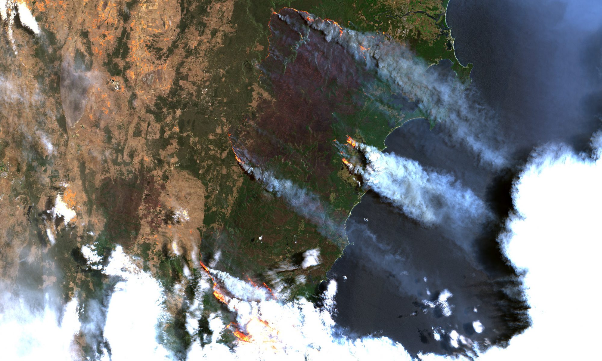
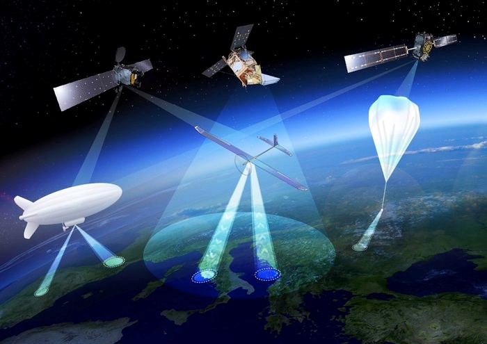
High Altitude Pseudo Satellites (HAPS) are geostationary or quasi-stationary stratospheric platforms that provide a link between the capabilities of satellites, UAVs and aircrafts. Positioned in the lower stratosphere, at a height of just over 20 km, they are close enough to the earth to provide high spatial resolution video and image data and at a distance far enough to uncover large land and ocean areas, continuously and in near real time.

They are ideally positioned to complement and expand the capabilities of satellites in earth observation, telecommunications and navigation and provide time-critical and permanent monitoring and communication solutions at relatively low cost.

Therefore, in the near future, HAPS platforms are expected to open up a new market for remote monitoring, enabling a time-critical and satellite-like monitoring that can support and contribute to several state and private applications and surveillance missions in defense and security, including patrol in Arctic, ship and air traffic monitoring, border patrol, etc.

This project aims to define the specific need for HAPS-based monitoring solutions in Denmark and at the same time identify opportunities for Danish technology companies to contribute relevant technology that can support the development of HAPS solutions, including the development of miniaturized sensors and communication systems.

Center for Defence, Space & Security:

The Center for Defence, Space & Security (CenSec) is the prime Danish cluster for small and medium-sized enterprises specializing in high tech industries like defence, homeland security, space, aerospace, railway and maritime.

CenSec was founded in 2004 and established in 2007 as an industrial cluster. In 2018, CenSec was approved by the Danish Ministry of Higher Education and Science to also become a national Innovation Network for Security (Inno-Sec)

EOatDHI part of the DHI GROUP

gras@dhigroup.com
+45 4516 9100

Agern Alle 5,
2970 Hørsholm,
Denmark

CVR: 36466871

Global Seas

Why is it important?

High-quality and reliable data on past, present and predicted conditions of various metocean parameters is essential in order to reduce fuel consumption, lower emissions and improve fleet management capacity in the shipping industry. DHI’s Global Seas will deliver hourly information on ocean current, wave and wind data one-year back and five days ahead in time, globally, through a series of accurate regional ocean current models assimilated by satellite data input.

Project highlights:

Providing global-local high-quality ocean surface current data achieved by combining earth observation and modelling techniques in a semi-automated downscaling approach

Covering a wide range of metocean parameters with expert assessment of quality and only including sufficiently reliable data.

Ensuring flexibility, easy and efficient access to the data exactly where the information is needed in the workflow of the end-users. This includes exploiting the increased bandwidth expected from sitcom and GPS positioning of vessels typically communicated via AIS.

In more detail..

Global Seas will deliver earth observation enriched high-quality data on ocean currents and other valuable metocean data tailored for application in the shipping sector with the purpose of making shipping more fuel efficient and ensure better management of the fleets.

The value creation will come from reduced fuel consumption, lower emissions and improved fleet management capacity. This is typically obtained by the shipping companies directly, by route optimization and fuel optimization service providers and by the vessel navigators and captains.The decisions made by the various players are complex on their own, but rely on the quality of past, present and predicted conditions of ocean currents, wind, waves, water level, sea temperature, salinity and other metocean conditions.

Global Seas focuses on generating value by providing easy and efficient access to current and other metocean high-quality data and estimating the accuracy of the data provided. This solution relies most heavily on altimetry-based sea surface height products combined with DHI’s world leading hydrodynamic models. Sea surface observations are used both for continually updating the tidal water level and current products, and it is the most important satellite observation for constraining mesoscale dynamics.

While emphasis is on ocean currents, the product will also integrate sea surface temperature (SST, from e.g. Sentinel 3A and 3B SLSTR), scatterometer surface wind speed data (from e.g. ASCAT, RapidScat), wave height and wind speed from altimetry

European Space Agency:

The European Space Agency (ESA) is the European space programme and its mission is to explore Earth, its immediate space environment, our Solar System and the Universe.

ESA also works closely with space organisations outside Europe to develop satellite-based technologies and services, and to promote European industries.

EOatDHI part of the DHI GROUP

gras@dhigroup.com
+45 4516 9100

Agern Alle 5,
2970 Hørsholm,
Denmark

CVR: 36466871

Monitoring & Assessment of Climate Change Impact on Geomorphology in the Coastal Areas of Bangladesh

Why is it important?

The vulnerability of the coastal population in Bangladesh is on the rise due to climate change. In order to identify and adopt best practice measures to increase the resilience of the coastal population to natural disasters and climate change, it is critical to assess and understand the changes and dynamics of the coastal zone. This project aims to build sustainable capacity among technical staff as well as decision makers to utilize modern satellite-based techniques to monitor climate change challenges and to provide early warning in the coastal zone of Bangladesh

Project highlights:

Providing a detailed baseline of existing GIS and earth observation data handling capacities among key stakeholders in Bangladesh

Capacity building within the use of satellite imagery for effective, systematic and routinely monitoring of coastal areas in Bangladesh with a view to assess climate change impacts.

Provision of on-site tailormade technical workshops focusing on application of EO techniques and coupled local field surveys.

In more detail..

The project is intended to establish methodological guidelines and step-by-step workflows for Earth Observation based assessments of coastal zone dynamics in Bangladesh, and train staff in developing early warning capacity for bank erosion attacks, which is one of the most significant risks from climate change.

Furthermore, the EO based workflows will allow stakeholders to increase the general understanding of the morphological processes in the coastal zone of Bangladesh and the impacts of climate change on these processes.

The project will contribute significantly to develop the technical ability of key stakeholders within relevant government agencies in Bangladesh, to conduct time-critical analysis of erosion/accretion processes and assessments of climate change impacts using advanced remote sensing methods.

Long term linear regression - indicates areas that are getting wetter (blue) or drier (red)
Fractional water coverage

Climate Technology Centre and Network:

The Climate Technology Centre and Network (CTCN) is the operational arm of the UNFCCC Technology Mechanism, hosted by the UN Environment Programme and the UN Industrial Development Organization (UNIDO). The Centre promotes the accelerated transfer of environmentally sound technologies for low carbon and climate resilient development at the request of developing countries.

EOatDHI part of the DHI GROUP

gras@dhigroup.com
+45 4516 9100

Agern Alle 5,
2970 Hørsholm,
Denmark

CVR: 36466871

A seesaw between climate extremes – Mapping the Australian flooding’s from space

A seesaw between climate extremes - Mapping the Australian flooding’s from space

12 FEBRUARY 2020

Just three weeks ago, we mapped the impacts of the devastating bushfires in Australia, triggered by the driest and hottest year on record. Heavy rainfall over the weekend has been a welcome relief for millions of animals and has helped to subdue some of the fires in New South Wales, however in return, the torrential rain has caused major flooding’s in the coastal regions.

Using our automated satellite-based operational flood mapping tool, we have mapped the extent of the flooding’s in one of the worst affected areas, around the city of Nowra in the Shoalhaven region, just south of Sydney. While the flood map quantifies the severity of the flooding’s, satellite images are also ideally positioned to visualize its effects on the overall water environment, as illustrated in the video.

So while the seesaw of events in Australia is a testimony to the unsustainable trajectory of our planet, we believe we are part of the solution – by bridging critical earth observation data and relevant stakeholders, we enable decision makers to take confirmative actions to respond to the severity of climate change and act upon climate impacts.

Our satellite-based product portfolio are ideally positioned to provide rapid and cost-efficient information about the impact of climate change and climate induced extreme events.

Quantifying the impact of the Australian bushfires from space

Quantifying the impact of the Australian bushfires from space

16 JANUARY 2020

This year’s fire season in Australia is widely regarded as one of the most severe on record, causing detrimental damage to natural landscapes, wildlife, cities and critical infrastructure across the nation. Using data from NASA's MODIS satellites, we have detected an accumulated quarter of a million km2 affected by active bushfires, during the last two months, more than the total land mass of the United Kingdom.

We are saddened by the ferocious bushfires sweeping across Australia and devoted to continuing to deliver our impactful tools and services to assist authorities in responding and scaling efficiently and effectively during such disaster scenarios. Our satellite-based product portfolio is ideally positioned to provide rapid and cost-efficient information about fire risk, impact and movement, thus offering critical tools for fire response. As an example, our high-resolution soil moisture product can be applied nationwide to conduct largescale assessments of fire risk.

Driven by our passion for change and curiosity about innovative and integrated satellite-based solutions, we continue to explore avenues to support decision makers in making critical evidence-based decisions.