NANOK – Nautical Navigation Operational Knowledge

Why is it important?

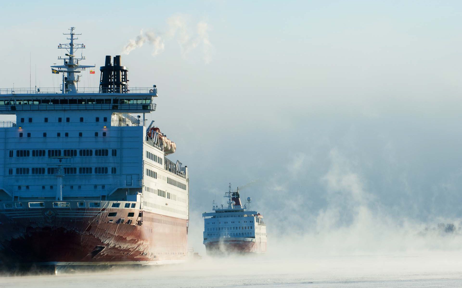
Maritime operations in the Arctic are often associated with high level of navigational risk since access to reliable nautical charts is limited by the fact that existing charts are often several nautical miles off, with vast areas still uncharted.

Meanwhile, the level of human activity in the Arctic is increasing. Climate changes widens the areas of operation in the Arctic, with ice-free conditions, enabling expansion of economic activities, access to natural resources and opening of new shipping routes. Also, increased research and tourism activities leads to an increase in marine traffic across the Arctic region.

In all, this leads to an enlarged geopolitical awareness of the Arctic region and in turn also an intensified military awareness and presence in the region.

The Danish Defense undertakes several tasks in the Arctic, including enforcement of sovereignty, search and rescue operations, fishing controls as well as societal tasks, e.g., scientific and medical logistical support. In this context NANOK provides the much-needed navigational situational awareness reducing navigational risks in the Arctic region.

Project highlights:

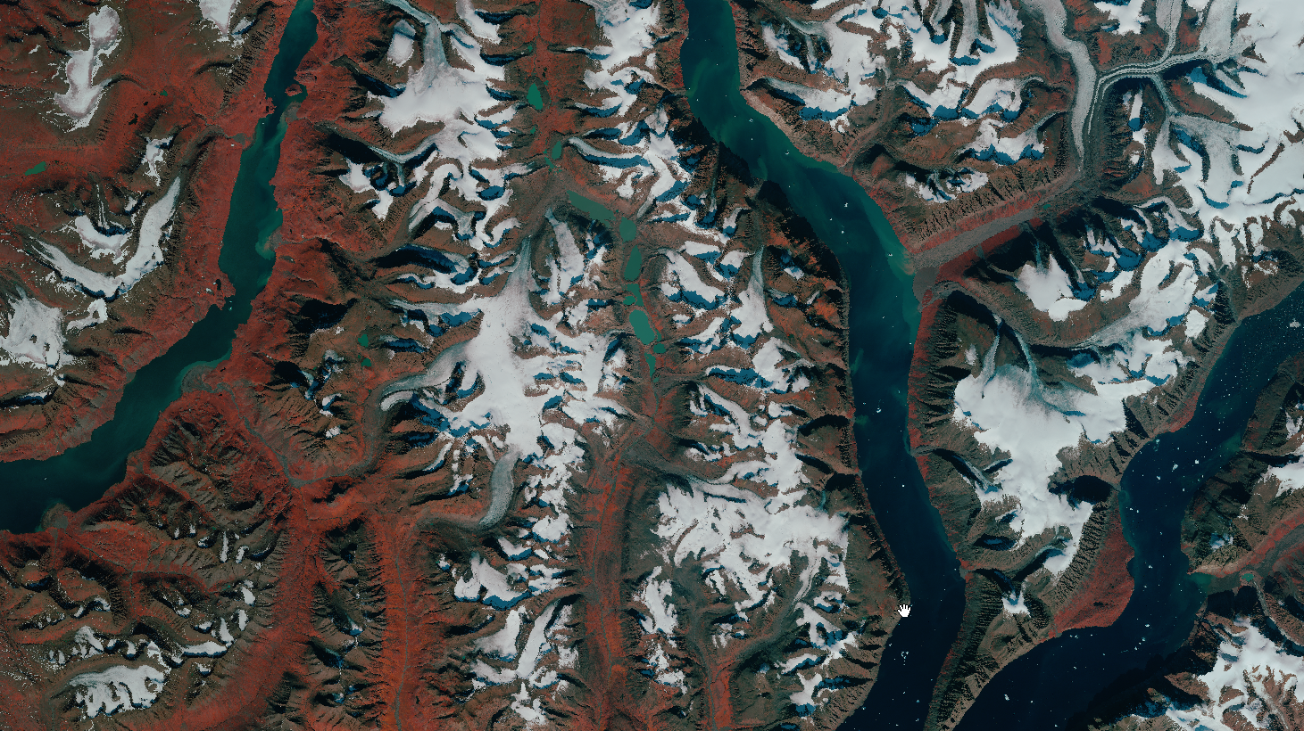
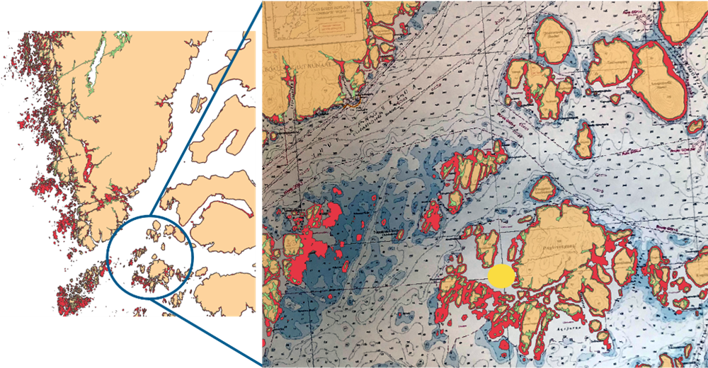
NANOK develops an automation and upscaling feasibility study of navigational hazards including 1) submerged rocks, 2) coast lines and 3) intertidal zones applicable to all arctic regions.

The NANOK data products are tailored to naval navigation systems and user requirements.

NANOK data products are processed in a cloud-computing environment allowing rapid data production and updating.

In more detail..

Maritime activity across the Arctic is increasing together with an increased geopolitical awareness in the region. Maritime operations in the Arctic are associated with high level of navigational risk since access to reliable nautical charts is limited by the fact that existing charts are often several nautical miles off, with vast areas still uncharted.

This situation often leaves navigators with on board equipment such as different types of sonar systems, offering little decision support on route planning and forward-looking situational awareness at a larger scale. The activities in the NANOK project are expected to significantly support route planning and situational awareness for a wide range of both civil and naval tasks.

NANOK is co-financed by and developed in collaboration with the Danish Defence and data products are consequently tailored to specific naval user requirements through dialogue-based co-production and onboard field testing.

The NANOK project develops Arctic navigational risk minimization by mapping submerged rocks, intertidal zones and coast lines. It includes an automation and upscaling feasibility test in Greenland of two previously developed remote sensing processing chains:

  • Mapping of Arctic shallow water areas using a DHI GRAS proprietary multitemporal bathymetric retrieval model based on open-source satellite data, validated against in-situ multi-beam echo sounding data.
  • Mapping of Arctic coastlines using a DHI GRAS proprietary method involving satellite data, intertidal information, machine learning.
The project reaches out to international Arctic stakeholders paving the way for a further product development and pan-arctic navigational risk minimization.

NANOK is co-financed by the Danish Defence Acquisition and Logistics Organization and DHI GRAS and is supported by the Danish Naval Warfare Centre and the Danish Defence Joint GeoMETOC Support Center.

Related items

EOatDHI part of the DHI GROUP

gras@dhigroup.com
+45 4516 9100

Agern Alle 5,
2970 Hørsholm,
Denmark

CVR: 36466871

Digital Ortho Photos of Ice free Greenland from existing Satellite imagery 2020

Why is it important?

Topographic maps of Greenland are generally outdated, and the positional accuracy often inadequate, in the open land outside the main settlement areas.

This means that critical decisions relevant for public administration and environmental regulation are often based on inadequate data and information, thus impeding the ability of authorities to make informed and data driven decisions rooted in the best possible data.

The new up to date orthophoto mosaics based on the latest satellite imagery from the Airbus Spot 6/7 satellites will contribute to address this gap by providing a fresh view of the ice-free areas of Greenland.

Project highlights:

Provision of very high resolution satellite imagery covering 225.000 km2 of Greenland

Advanced large scale data processing to produce seamless cloud-free, orthorectified and color optimized image mosaics covering the entire 225.000 km2.

Independent advice and support on satellite data selection and processing, drawing upon more than 20 years’ experience

In more detail..

Since 2015, DHI GRAS has supported the Danish Agency for Data Supply and Efficiency (SDFE), in close cooperation with Greenland’s Government, in their mission to provide updated topographic maps of the ice-free areas of Greenland.

The current topographic maps of Greenland are based on data collected in the 1930s and 1970-80s and they are inaccurate both in terms of elevation, distance and geolocation. However, Greenland is a large country and combined with the extreme conditions, dark polar winters and frequent cloud cover makes it difficult and costly to map at scale through traditional means.

Through previous pilot projects (undertaken in collaboration with Airbus on behalf of SDFE), we have provided ready-to-use orthomosaics and detailed Digital Elevation Models (DEM) for an area covering 85.000 sqkm of Greenland, successfully demonstrating the viability and potential of satellite imagery as a solution to the existing data gap.

In this project (in collaboration with Airbus) we will deliver updated satellite ortho image mosaics for the majority of the ice-free areas of Greenland – covering an extent of more than 225.000 km2.

These new data, providing a fresh view of Greenland, will underpin efforts to update existing topographic maps, thus contribute to support informed decision making and make it easier and more secure to navigate in the vast Greenlandic nature.

In partnership with

Danish Agency for Data Supply and Efficiency:

The Danish Agency for Data Supply and Effeciency (SDFE) provides high-quality data to the public and private sectors, enabling them to make important community decisions on the best possible basis.

SDFE is an agency that spans broadly across public administration and is part of the Danish Ministry of Climate, Energy and Utilities.

Related items

EOatDHI part of the DHI GROUP

gras@dhigroup.com
+45 4516 9100

Agern Alle 5,
2970 Hørsholm,
Denmark

CVR: 36466871

Satellite-derived bathymetry for nautical navigation

Satellite-derived bathymetry

The challenge:

Greenland Pilot Service provides navigational safety services in the Arctic region and their strategy is to contribute to a safe development of the cruise industry in polar regions.

They embark experienced and licensed Polar Code Compliant Pilots on board the cruise vessels. The Pilots contribute with local knowledge and experience, to strengthen the bridge team, ensuring a safe and effective operation.

The 24/7 manned operations center in Nuuk carries out all mandatory Risk Assessments, and continuously updates the pilots with daily information on weather and ice.

To be able to operate safely and ensure best practice, they needed updated information about coastlines and submerged hazards in the poorly charted shallow coastal area around Skjoldungen, Greenland.

Project highlights:

Updated and accurate mapping of coastlines including at high and low tide

Location and size of submerged hazards mapped with clear depiction of small and large submerged hazards

Updated spatial information ensuring safe transport of vessels, ideal for large and remote areas

Project Manager,
Thomas Bøggild

With the help of satellite-derived bathymetry from DHI GRAS we were able to make a proper navigational risk assessment enabling our clients to safely access the remote and poorly charted waters around Skjoldungen. DHI GRAS did a great job in helping us understand the value of the data and delivery was fast and on time

In more detail..

We were commissioned by the client to provide them with accurately mapped coastlines at both low and high tide, as well as identify submerged hazards, such as reefs, rocks and sand banks.

Sentinel images provided the raw data, which were then analysed and validated. The information derived from satellites is much more accurate than existing nautical charts in the Arctic and allowed Greenland Pilot Services to safely enter the waters around Skjoldungen.

A pilotage company specialised in assisting masters and navigators in their operations in Polar regions.

They carry out mandatory risk assessments and contingency planning according to relevant laws and regulations as well as voyage planning while ensuring compliance with the Polar Code.

EOatDHI part of the DHI GROUP

gras@dhigroup.com
+45 4516 9100

Agern Alle 5,
2970 Hørsholm,
Denmark

CVR: 36466871

Updated satellite-based maps of Greenland

satellite map greenland

Why is it important?

The new cartographic data will contribute to supporting Greenland’s infrastructure management as well as its economic development.

Precise and detailed maps are also important in connection with climate and environmental monitoring, rescue preparedness and business development.

Project highlights:

Procurement of satellite imagery and Digital Elevation Models covering 85.000 sqkm of Greenland

Facilitating topographic mapping of a large and remote area with high accuracy and without risks or need for mobilization

Independent advice and experienced support selecting the right satellite-based solution for the project purpose, based on close to 20 years of experience

The Danish Agency for Data Supply and Efficiency (SDFE) has produced a short video presenting their new 3D-panorama service, based on our data.

In more detail..

Since 2015, DHI GRAS has supported the Danish Agency for Data Supply and Efficiency (SDFE), in close cooperation with Greenland’s Government, in their mission to provide updated topographic maps of the ice-free areas of Greenland. The current topographic maps of Greenland are outdated and due to the large size of the country, it is not the easiest to map.

Together with our close partners at Airbus Defence and Space we have provided ready-to-use orthomosaics and detailed Digital Elevation Models (DEM) for an area covering 85.000 sqkm of Greenland.

The satellite data products were produced based on dedicated image acquisitions of up-to-date stereo satellite imagery from the SPOT 6 and 7 satellites.

Danish Agency for Data Supply and Efficiency:

The Danish Agency for Data Supply and Effeciency (SDFE) provides high-quality data to the public and private sectors, enabling them to make important community decisions on the best possible basis.

They are a workplace that spans widely and is part of the Danish Ministry of Climate, Energy and Utilities.

Related items

EOatDHI part of the DHI GROUP

gras@dhigroup.com
+45 4516 9100

Agern Alle 5,
2970 Hørsholm,
Denmark

CVR: 36466871