Satellite-based evidence of the abnormal dry conditions in Denmark

Satellite-based evidence of the abnormal dry conditions in Denmark:

10 August 2018

Copyright: DHI GRAS, contains Copernicus Sentinel data (2018)

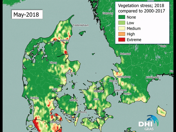
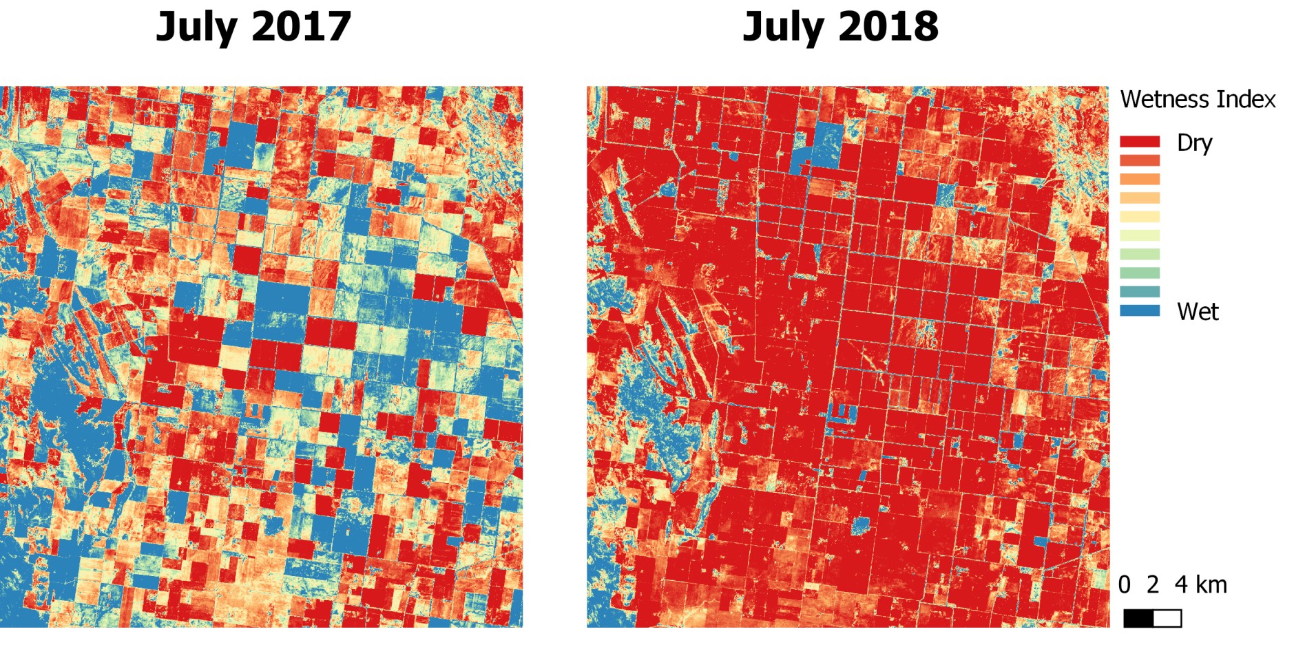
The analysis depicts how the vegetation stress of May, June and July 2018 differ from the average ‘normal’ conditions of the same months (measured as an average of observed vegetation stress in the period 2000 to 2017). The vegetation stress is based on an assessment of the water availability where green colours indicate ‘no change from the normal conditions’ and red colours indicate ‘extreme worsening compared to the normal conditions’. Let’s break this down further.

May 2018, being mostly green, had normal conditions in most of the country if you compare it to the 18 previous years, although some parts already deviated from the average of previous years (these are the yellow to red colours you see). Moving on to June 2018 the colours have shifted, and we now see more areas affected by lack of water compared to previous years; the drought conditions are worsening and beginning to affect crops and natural vegetation. During July the picture changes completely. The heat wave and lack of rain continues and almost the entire country is now experiencing an extreme deviation from the period of 2000 to 2017 or put more simply: highly unusual and extreme drought.

These extreme deviations come at a cost. A prognosis done by a Danish agricultural journal, indicates that the expected Danish grain harvest will be more than 35% below the last five years’ average harvest. If the prognosis sticks this will give Danish farmers, the worst harvest recorded since 1976. In addition, the grass harvest for livestock fodder is expected to be halved, and the coming harvest of maize has been reduced by 25-30%; if the drought persists the output will be reduced even further.

Farmers dealing solely with livestock are also feeling the heat. The low supply of grains and other types of fodder is seeing a rise in prices which farmers are having a hard time to pay for.

All in all, this is estimated to cost the Danish agricultural sector minimum 6,4 billion Danish crowns. A government grant to help farmers is now being put in place and will among other things try to secure enough fodder for livestock and give more flexibility in relation to the sowing of catch crops. Our analysis clearly illustrates and documents the extreme conditions we have experienced this summer and that the vast majority of Denmark is affected by the ongoing lack of rain.

EOatDHI part of the DHI GROUP

gras@dhigroup.com
+45 4516 9100

Agern Alle 5,
2970 Hørsholm,
Denmark

CVR: 36466871

Severe drought this summer

Severe drought this summer:

07 August 2018

It’s not just Europe that is suffering from severe drought after several weeks of extremely high temperatures.

Australia, where it’s winter right now, is experiencing the biggest shortage of precipitation in living memory. 99% of the state of New South Wales, the country’s fourth largest provider of agriculture output, is currently in drought. The situation is so dire that total government funding for farmers has now reached $576m.

The start of the bushfire season has also been pushed forward almost two months due to next to no rain with 525 bushfires across New South Wales recorded burning last week. This is almost double the number at the same time last year.

The states rural fire service is already looking nervously towards the coming of summer.

Below Sentinel-2 images from a rural area outside of Griffith, NSW shows you the wetness index in July 2017 compared to July 2018.

Copyright: DHI GRAS, contains Copernicus Sentinel data (2018)

EOatDHI part of the DHI GROUP

gras@dhigroup.com
+45 4516 9100

Agern Alle 5,
2970 Hørsholm,
Denmark

CVR: 36466871

Hydroelectric dam in southeast Laos collapses

flood and hazard mapping

Hydroelectric dam in southeast Laos collapses:

27 July 2018

Thousands affected after the collapse of the Xepian-Xe Nam Noy hydroelectric dam in southeast Laos. The billion-dollar hydropower project was still under construction when the breach occurred Monday evening local time, unleashing approximately 5 billion cubic meters of water onto the surrounding countryside, with many living close to the river system that feeds into the failed dam.

Laos aims to become the “battery of Asia” by selling power to neighbouring countries through a series of hydropower projects and plans to be operating 100 plants by 2020.

Sentinel-1 RADAR imagery has captured the dam on the 13th and 25th of July, showing the state of the area before and after the dam collapsed. The resulting flood is illustrated in blue and the empty reservoir in orange.

flood and hazard mapping
Copyright: DHI GRAS, contains Copernicus Sentinel data (2018)

EOatDHI part of the DHI GROUP

gras@dhigroup.com
+45 4516 9100

Agern Alle 5,
2970 Hørsholm,
Denmark

CVR: 36466871

International Day for the Conservation of Mangrove Ecosystems

International Day for the Conservation of the Mangrove Ecosystems:

16 July 2018

Did you know that:

- Mangroves reduce vulnerability to climate-related coastal hazards and ensure shoreline stabilization
- Mangroves provide habitats for many threatened species
- Mangroves are some of the most carbon-rich ecosystems
- Mangroves provide food security by sustaining fisheries and forest products for thousands of coastal communities

The stakes are high seeing as mangroves are among the most threatened ecosystems on earth with estimates indicating that up to 67% of mangroves have been lost to date.

DHI GRAS is leading the ESA funded GlobWetland Africa initiative which looks at exploiting the increasing capabilities of satellite observations to support the inventory, monitoring and assessment of mangroves. The project aims to provide African stakeholders with tools to effectively manage and conserve areas such as mangroves.

EOatDHI part of the DHI GROUP

gras@dhigroup.com
+45 4516 9100

Agern Alle 5,
2970 Hørsholm,
Denmark

CVR: 36466871

Eruption of the Kilauea Volcano

Eruption of the Kilauea Volcano:

19 July 2018

The ongoing eruption of Hawaii’s Kilauea Volcano continues to spew out lava and engulf more and more land.

The volcano is one of the most active in the world, and has already destroyed hundreds of homes and most recently injured 23 tourists that sailed too close to the flowing lava.

Sentinel-2 images in false color shows how the lava has flowed from the rift into Vacationland wiping out almost the entire neighbourhood and altering the landscape by moving the shoreline almost 1 km from its original location.

EOatDHI part of the DHI GROUP

gras@dhigroup.com
+45 4516 9100

Agern Alle 5,
2970 Hørsholm,
Denmark

CVR: 36466871

Drought in Denmark

Drought in Denmark:

18 July 2018

Drought is a major cause of limited agricultural productivity and of crop yield uncertainty. This is exactly why early detection of drought is important for managing crops to prevent and mitigate crop losses and prevent wild fires. Most of Europe is already seeing the consequences of the ongoing drought with a loss of crops and fires starting. To manage large areas, it can therefore be an advantage to use satellite images.

EOatDHI part of the DHI GROUP

gras@dhigroup.com
+45 4516 9100

Agern Alle 5,
2970 Hørsholm,
Denmark

CVR: 36466871

Solar Pandas

Celebrating Solar Pandas:

16 July 2018

Spotted: A solar farm in China shaped as pandas (captured by Sentinel-2).

The panda-shaped solar farms aim to support the development of renewable energies and to promote public awareness on eco-friendly technologies and sustainable development, in particular among young people.

Copyright: DHI GRAS, contains Copernicus Sentinel data (2018)

EOatDHI part of the DHI GROUP

gras@dhigroup.com
+45 4516 9100

Agern Alle 5,
2970 Hørsholm,
Denmark

CVR: 36466871

Classification of Eelgrass

Classification of Eelgrass:

11 July 2018

One of our own, James Ormond Fethers, recently graduated from Aalborg University Copenhagen with a master’s degree in Geoinformatics. James worked alongside remote sensing experts in DHI GRAS for his master thesis on classification of eelgrass in Roskilde Fjord using Sentinel-2 imagery.

Eelgrass is a significant and fragile species of seagrass that is commonly found in Denmark and the Northern Hemisphere, and the coverage and depth limit can be used for evaluating the ecological condition of coastal waters.

Satellite remote sensing has the potential to improve the cost effectiveness of this analysis significantly by measuring coverage and directing field surveys to determine the depth limit.

James will be speaking at “Kortdage 2018” in Aalborg on the 14th-16th of November, where he will introduce and demonstrate his thesis in more detail. Stay tuned ..

EOatDHI part of the DHI GROUP

gras@dhigroup.com
+45 4516 9100

Agern Alle 5,
2970 Hørsholm,
Denmark

CVR: 36466871

Roskilde Festival

Roskilde Festival:

05 July 2018

These days the largest North European culture and music festival is taking place.

The festival covers an area that corresponds to 350 football fields, with around 130,000 participants moving in for the week-long party making Roskilde Festival the fourth largest city in Denmark in terms of population.

Sentinel-2 has captured the area on the 4th of June (before the festival started) and again on the 4th of July (four days into the festival).

Can you spot orange stage?

*Notice how the drought has turned the surrounding fields from green to brown.

EOatDHI part of the DHI GROUP

gras@dhigroup.com
+45 4516 9100

Agern Alle 5,
2970 Hørsholm,
Denmark

CVR: 36466871

Image composites for cloud-free monitoring

Image composites for cloud-free monitoring:

03 July 2018

Our very own junior geoinformatic specialist, Mike, just graduated from Aalborg University Copenhagen with a master’s degree in Geoinformatics.

His master thesis was done in close collaboration with our remote sensing experts here at DHI GRAS using Sentinel-2 imagery.

One main challenge for satellite imagery analysis is cloud cover, especially when working with time sensitive objects such as crop type classification and crop yield estimation.

Mike looked at how the implementation of image composites could be beneficial for cloud-free crop type monitoring and classification and found that creating monthly composites provided an increase of 23.5% in the total number of fields available for classification in the area of interest.

On a wider scale, the composites provide a big opportunity for monitoring and classification of land cover and land use in cloudy and rainy areas, such as the wet season in Africa or South-East Asia and could make crop yield estimates more reliable.

Below you can get an idea of how piecing together images from different days with differing cloud cover can result in an almost cloud-free image to do the further analysis on.

EOatDHI part of the DHI GROUP

gras@dhigroup.com
+45 4516 9100

Agern Alle 5,
2970 Hørsholm,
Denmark

CVR: 36466871