SAR4SAR – Enhancing Arctic Search and Rescue operations using radar satellite imagery
Exploring new avenues to enhance radar satellite-based object detection for Search-and-Rescue operations in the Arctic.

Analysing and documenting the information needs and operational constraints of maritime authorities and vessel operators in Greenland, with a focus on navigation safety in shallow, poorly charted coastal waters
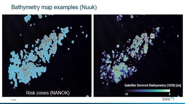
Assessing and developing Earth observation methods to detect submerged navigational hazards, estimate shallow‑water bathymetry, and reconstruct spatially varying tidal conditions using satellite data and machine learning.
Demonstrating how EO‑derived coastal hazard intelligence can support safer maritime operations, improved situational awareness, and better preparedness for navigation and emergency response in Arctic waters.
The project integrates multiple Earth observation data sources, including Sentinel 2 optical imagery, ICESat 2 altimetry, and sea surface height measurements from the SWOT mission, combined with machine learning models tailored to Arctic coastal environments.
A central innovation of EO4Hazards is the reconstruction of spatially varying tidal conditions using SWOT data, closing a long standing information gap in narrow fjords and near shore waters where conventional satellite altimetry and tide gauges are unavailable. These tidal estimates are used to correct and contextualise shallow water bathymetry products, enabling more robust identification of hazardous zones relevant for navigation.
The project focuses on selected areas along Greenland’s west coast, including fjords and coastal approaches where traditional hydrographic surveys are sparse or non existent. All workflows are designed for scalability, enabling rapid large area mapping that would be impractical using vessel based surveys alone.
EO4Hazards places strong emphasis on operational relevance. The generated products are tested and evaluated in collaboration with maritime authorities and operators, ensuring that outputs are fit for real world use and can be delivered in formats compatible with existing navigation and planning systems.
It is led by DHI in collaboration with DTU Space and the Greenland Institute of Natural Resources.
Exploring new avenues to enhance radar satellite-based object detection for Search-and-Rescue operations in the Arctic.
Large scale mapping of submerged rocks, intertidal zones and accurate delineation of coastlines across the Arctic region.
Provision of detailed satellite imagery and digital elevation models covering 85.000 sqkm of Greenland Up