SAV Sweden 2.0 – Automated national monitoring of submerged aquatic vegetation
SAV Sweden 2.0 upgrades the existing SAV Sweden platform into a fully automated, deep learning based system for nationwide detection of spatio temporal changes in submerged aquatic vegetation using Sentinel 2 satellite data.
Why is it important?
The original SAV Sweden project established the first national-scale, satellite-based mapping of submerged aquatic vegetation in Sweden and demonstrated the feasibility of Sentinel‑2 data for supporting national monitoring and reporting under EU environmental directives. Building on this foundation, SAV Sweden 2.0 addresses the growing need for continuous, objective, and cost‑efficient monitoring of change over time. Authorities increasingly require not just static habitat maps, but automated detection of trends and spatial changes to support management actions, reporting obligations, and early warning of ecological degradation. SAV Sweden 2.0 enables this transition by moving from semi‑automated mapping towards a fully automated, operational monitoring system.
Project highlights:
SAV Sweden 2.0 transforms the semi‑automated workflows used in SAV Sweden 1.0 into a fully automated Sentinel‑2 processing chain, enabling systematic and repeatable production of shallow coastal habitat maps without the need for manual interpretation or user‑generated annotations.
A pre‑trained deep learning model is integrated as the core mapping engine, replacing user‑dependent training workflows from the earlier system. This increases objectivity, robustness, and scalability of SAV classification, while ensuring consistent application across Sweden.
New functionality enables spatio‑temporal change and trend analysis of submerged aquatic vegetation distribution, linked to an alerting mechanism that supports early identification of significant changes relevant for environmental management and reporting.
In more detail..
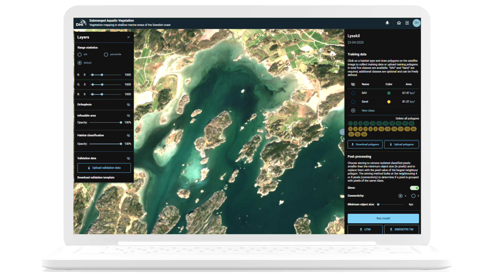
SAV Sweden 2.0 builds directly on the results, experience, and operational setup established through SAV Sweden 1.0, which was developed by DHI on behalf of the Swedish Agency for Marine and Water Management in collaboration with the County Administrative Board of Västerbotten.
First implemented as a prototype during 2020–2021, SAV Sweden 1.0 is now actively used by authorities to map underwater habitats along the Swedish coast using Sentinel 2 imagery.
Since 2022, DHI has been responsible for operating and maintaining the SAV Sweden platform, ensuring stability, security, and adaptation to evolving services within Digital Earth Sweden (RISE). This long term responsibility gives DHI detailed insight into system performance, limitations, and maintenance needs—providing a strong foundation for a controlled and efficient upgrade.
The SAV Sweden 2.0 project modernises the platform by automating the Sentinel 2 based analysis pipeline, updating models and software components, and replacing outdated elements to ensure long term robustness and cost efficiency. Central to the upgrade is the integration of a pre trained deep learning model, which minimises reliance on user generated annotations and enables automated generation of multi temporal shallow coastal habitat maps.
Additional enhancements include upgrading the existing static feasibility layer to an image specific, dynamic approach, improving classification reliability under varying conditions. A dedicated change and trend analysis module is developed and linked to an alerting system, enabling systematic monitoring of underwater vegetation dynamics over time.
All new functionality is integrated into SAV Sweden 2.0 and implemented on Digital Earth Sweden (RISE), ensuring continuity with the existing operational infrastructure while significantly expanding analytical capabilities.
Länsstyrelsen Västerbotten
SAV Sweden 2.0 is developed by DHI on behalf of the Swedish Agency for Marine and Water Management, in collaboration with the County Administrative Board of Västerbotten. The project builds directly on the operational SAV Sweden platform already in use by Swedish authorities.
